
> From the WeatherWatch archives
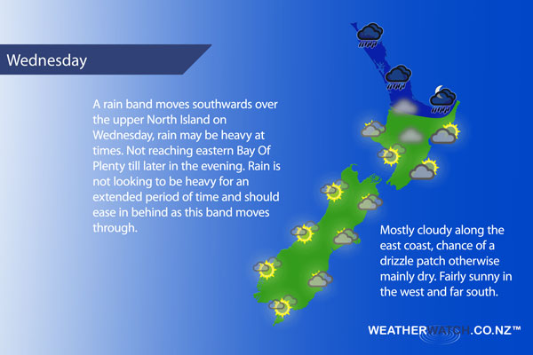
A fairly slack pressure gradient on Wednesday (not much wind flow) however a front moves southwards over the upper North Island during the day.
Rain in the morning (possibly heavy) about Northland and Auckland then moving into the Waikato and Bay Of Plenty in the afternoon, easing in the north from afternoon and further south in the evening. There may be some morning fog about the Waikato. Light winds.
Lower western North Island. Sunny areas and increasing high cloud after any morning fog breaks, showers or perhaps some rain developing later in the day / overnight. Light winds. Sunny areas and increasing cloud along the east coast, a few showers develop later in the day / overnight. Light easterlies.
Sunny areas and increasing cloud for Wellington, southeasterly winds pick up from afternoon.
Becoming mostly cloudy in the morning about Nelson and Marlborough, light winds. Mostly cloudy for Canterbury, there may be a drizzle patch or two otherwise mainly dry. Light easterlies.
Mostly sunny with some high cloud along the West Coast, lower level cloud increases in the evening. Light winds. Mostly sunny about Southland and Central Otago, some high cloud from afternoon. Coastal Otago sees mostly cloudy skies, some sun may break through at times. Light winds.
Blue – Heavy form of precipitation or cold temperatures, typically below 1 to 2 degrees celsius.
White – Snow
Purple – Strong winds.
Yellow – Temperatures around the mid 20 degree mark or over.
Not all regions and towns have been mentioned above. For specific 10 day information for your city, town, rural community or island please see the 1500 forecasts on our homepage!
– Aaron Wilkinson, WeatherWatch.co.nz
Latest Video

Wintry weather coming: Snow, rain, wind & sunshine
A cold front is moving into NZ from Friday to Sunday with low pressure developing west of NZ and then…
Related Articles

Polar airflow + northern low = pockets of heavy rain & snow
A colder change is coming – and so too is a large low which will develop and grow over northern…
Wintry weather coming: Snow, rain, wind & sunshine
A cold front is moving into NZ from Friday to Sunday with low pressure developing west of NZ and then…

ClimateWatch: JULY outlook & what El Niño means for NZ
El Niño is officially here and still getting stronger in the months ahead, but it’s harder to notice its effects…

