InfoGraphic: The Big Picture for Wednesday / Thursday
18/06/2019 7:00pm

> From the WeatherWatch archives
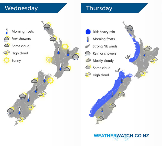
An anticyclone covers the country today. This anticyclone moves off to the east on Thursday, this combined with a low pressure system to the west directs a northerly airflow over New Zealand, a front pushes into western areas during the day.
Fairly settled and mostly sunny for a majority of the country today, some cloud from afternoon for Auckland and Northland, there may even be a light shower or two move into far northeastern areas. Cloudy areas for Hawkes Bay and Gisborne, a shower or two brushing the coast (i.e. Mahia Peninsula). Mostly cloudy for the West Coast of the South Island, a shower or two about South Westland from afternoon then North Westland later in the evening.
Dry for eastern New Zealand on Thursday but expect plenty of high cloud. Cloudy in the west with rain or showers about South Westland and Northland, gradually pushing into other western regions by evening and possibly becoming heavy.
By Weather Analyst Aaron Wilkinson – WeatherWatch.co.nz
Latest Video

Matariki, the long weekend + the outlook for next week
Wet weather and cloud continues along the eastern side of the country with the heaviest rain now moving into northern…
Related Articles
Matariki, the long weekend + the outlook for next week
Wet weather and cloud continues along the eastern side of the country with the heaviest rain now moving into northern…

More eastern rain, but a drier long weekend coming
Rain continues today along the eastern South Island and lower North Island, coming in from the east with heavy falls….

More heavy rain, snow – but large dry areas, especially as we go into the long weekend
Heavy rain will continue for parts of Canterbury and Marlborough over the next day or two and it will gradually…

