InfoGraphic: The Big Picture for Wednesday / Thursday
19/02/2019 6:00pm

> From the WeatherWatch archives
A cold front quickly weakens over the South Island today as a ridge builds over both Islands extending out from an anticyclone to the east of New Zealand in the Pacific. A ridge hangs over New Zealand on Thursday however not all is settled, high moisture may lead to afternoon heavy showers about central North Island regions and a frontal feature over the South Island brings some rain in the west.
Mostly sunny for a fair majority of the North Island today, a shower or two can be expected about Northland however especially afternoon, perhaps also northern parts of Auckland. A few light morning showers possible for southwestern areas then breaking to sun in the afternoon. Morning heavy rain for the West Coast then quickly easing, early cloud clears then becoming mostly sunny about Southland and Otago. Mainly dry elsewhere for the rest of the South Island although there may be an isolated shower for Marlborough late afternoon / evening.
Showers and sunny spells for most North Island regions on Thursday, showers may become heavy during the afternoon for some inland areas then easing in the evening. Rain or showers for the West Coast of the South Island for much of the day, mainly dry elsewhere however there may be an isolated shower or two about Otago in the afternoon.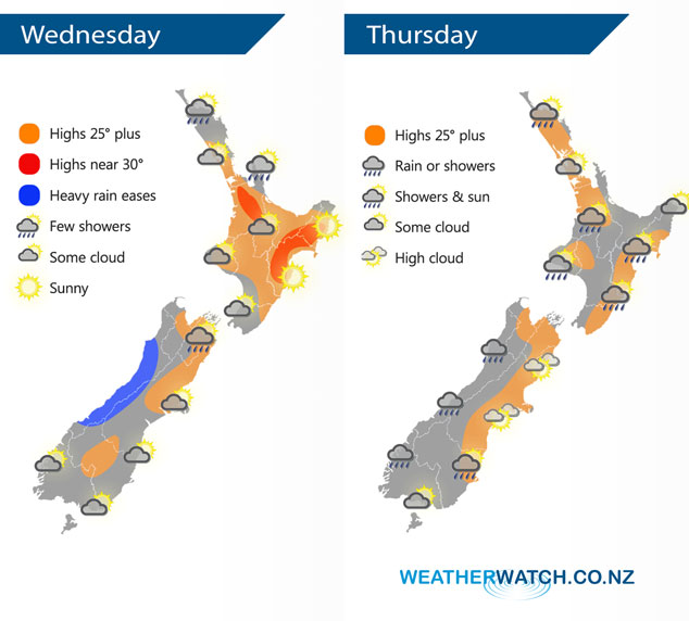
By Weather Analyst Aaron Wilkinson – WeatherWatch.co.nz
Latest Video

Matariki, the long weekend + the outlook for next week
Wet weather and cloud continues along the eastern side of the country with the heaviest rain now moving into northern…
Related Articles
Matariki, the long weekend + the outlook for next week
Wet weather and cloud continues along the eastern side of the country with the heaviest rain now moving into northern…

More eastern rain, but a drier long weekend coming
Rain continues today along the eastern South Island and lower North Island, coming in from the east with heavy falls….

More heavy rain, snow – but large dry areas, especially as we go into the long weekend
Heavy rain will continue for parts of Canterbury and Marlborough over the next day or two and it will gradually…

