InfoGraphic: The Big Picture for Wednesday / Thursday
20/02/2018 6:00pm

> From the WeatherWatch archives
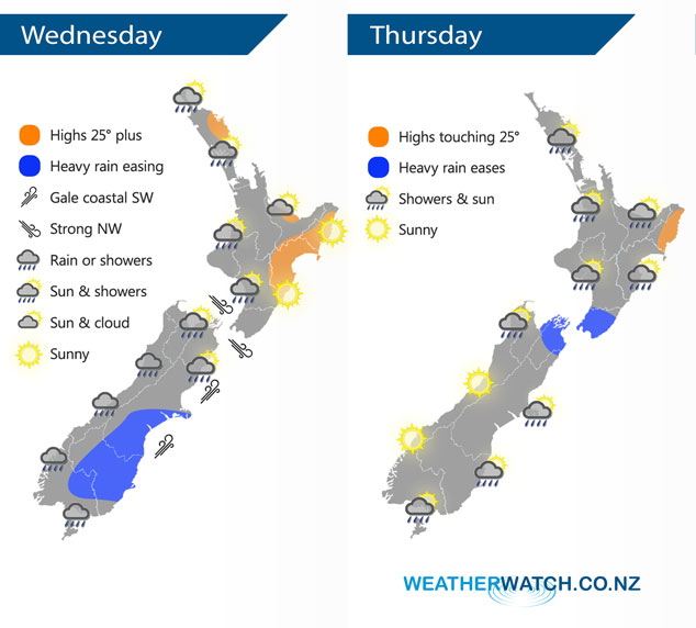
The main low pressure system associated with Ex Tropical Cyclone Gita lies east of the South Island today meanwhile another low sits west of the South Island. A northwest airflow lies over the North Island. A low moves over the North Island on Thursday while southwesterlies ease further south.
A few showers for western parts of the North Island today, more likely Taranaki southwards but a few are possible further north also especially this morning. Any morning cloud clears the Bay Of Plenty then mostly sunny.
Rain or showers for most South Island regions, heavy rain Banks Peninsula southwards eases this morning, not easing about parts of Otago till late afternoon / evening. Expect gale southwesterly winds for the coastal parts of the eastern South Island, severe gales possible out on Banks Peninsula. These winds will gradually ease during the day.
Strong northwesterlies through Cook Strait ease in the afternoon then winds change southerly in the evening bringing some rain.
Most North Island regions will see showers on Thursday, easing during the afternoon in the west and sunny areas then developing. In the east conditions are dry at first then showers push northwards with a southwest change. Early rain about central New Zealand which may be heavy eases. Morning showers about the lower South Island and some eastern coastal areas clears then drying out in the afternoon, sunnier conditions out west.
By Weather Analyst Aaron Wilkinson – WeatherWatch.co.nz
Latest Video

Wintry weather coming: Snow, rain, wind & sunshine
A cold front is moving into NZ from Friday to Sunday with low pressure developing west of NZ and then…
Related Articles
Wintry weather coming: Snow, rain, wind & sunshine
A cold front is moving into NZ from Friday to Sunday with low pressure developing west of NZ and then…

ClimateWatch: JULY outlook & what El Niño means for NZ
El Niño is officially here and still getting stronger in the months ahead, but it’s harder to notice its effects…

Low pressure heading to NZ this weekend & into next week
Many regions have settled weather at the moment with frosts as far north as Auckland this morning, but still some…

