InfoGraphic: The Big Picture for Wednesday / Thursday
15/05/2018 7:00pm

> From the WeatherWatch archives
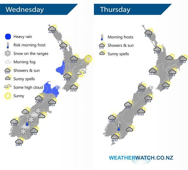
A low passes over and away to the east of New Zealand today gradually letting in a cold southwesterly airflow. This southwesterly airflow continues on Thursday with a front passing over the North Island during the day and another moving onto the lower South Island in the afternoon.
Showers for the North Island today, especially in the west and north during the afternoon / evening as a front moves over. Showers may be heavy at times, perhaps even some thunder. A mainly dry day for Hawkes Bay and Gisborne.
Early heavy rain eases about Nelson / Marlborough then expect the odd shower. A few early showers clear for the central South Island then some sun may break through, later on a cold south to southwest change brings rain with snow developing on the mountain ranges. A chance of frost and fog this morning for the lower South Island, especially inland. A dry start for Southland and Otago then rain developing with cold southwesterly winds, snow develops on the mountain ranges for a time before clearing overnight.
Showers for most North Island regions on Thursday, especially in the west. The same goes for the South Island although after any morning showers clear the east coast experiences a mainly dry day. A frosty start for inland parts of the lower South Island.
By Weather Analyst Aaron Wilkinson – WeatherWatch.co.nz
Latest Video

Wintry weather coming: Snow, rain, wind & sunshine
A cold front is moving into NZ from Friday to Sunday with low pressure developing west of NZ and then…
Related Articles
Wintry weather coming: Snow, rain, wind & sunshine
A cold front is moving into NZ from Friday to Sunday with low pressure developing west of NZ and then…

ClimateWatch: JULY outlook & what El Niño means for NZ
El Niño is officially here and still getting stronger in the months ahead, but it’s harder to notice its effects…

Low pressure heading to NZ this weekend & into next week
Many regions have settled weather at the moment with frosts as far north as Auckland this morning, but still some…

