
> From the WeatherWatch archives
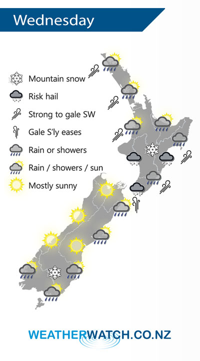
A strong southerly quarter change moves over the North Island on Wednesday, conditions gradually ease further south. Overnight a further cold southwest change moves onto the lower South Island.
Heavy rain or showers for most North Island regions on Wednesday morning, hail possible also. Conditions easing in the west from afternoon then along the east coast in the evening. Expect strong to gale southwesterly winds for some coastal areas especially Northland and Auckland then easing by evening. Some snow about hills and ranges of the lower North Island down to 500m.
A sunny day for the West Coast of the South Island and Nelson, early heavy showers and snow to 500m about Marlborough clears then afternoon sun breaks through. Heavy rain or showers about Canterbury with a risk of hail then easing, clearing South Canterbury in the morning then further north in the afternoon. Some snow about Canterbury to 300m before clearing. Morning showers and snow flurries to 300m about Southland and Otago clear then sun breaks through, later in the evening or overnight rain moves in with a gusty SW change.
By Weather Analyst Aaron Wilkinson – WeatherWatch.co.nz
Latest Video

Matariki, the long weekend + the outlook for next week
Wet weather and cloud continues along the eastern side of the country with the heaviest rain now moving into northern…
Related Articles
Matariki, the long weekend + the outlook for next week
Wet weather and cloud continues along the eastern side of the country with the heaviest rain now moving into northern…

More eastern rain, but a drier long weekend coming
Rain continues today along the eastern South Island and lower North Island, coming in from the east with heavy falls….

More heavy rain, snow – but large dry areas, especially as we go into the long weekend
Heavy rain will continue for parts of Canterbury and Marlborough over the next day or two and it will gradually…

