InfoGraphic: The Big Picture for Tuesday / Wednesday
27/01/2020 6:00pm

> From the WeatherWatch archives
Fairly anticyclonic today however a weak area of low pressure sits just to the east. A northwesterly airflow lies over the country on Wednesday, a front pushes northwards over the South Island during the day meanwhile a trough comes out of the Tasman Sea over the upper North Island.
Some cloud may bring a light shower or two for the western North Island today mainly south of about Waikato, sunnier conditions likely out east. A chance of early fog about inland Waikato also. The West Coast of the South Island is mostly cloudy with showers, easing during the day and dry spells increasing. High cloud and mainly dry in the east although a few isolated showers are possible about the far south.
The odd shower for the western / upper North Island on Wednesday, showers may become heavy in the afternoon about Bay Of Plenty and Northland. Mainly dry in the east however a few spits or isolated showers are possible about Hawkes Bay / Gisborne in the afternoon then clearing evening. Morning rain may be heavy for the West Coast of the South Island then easing to showers, mainly dry in the east. Some morning rain passes through the far south then dry spells develop, further showers move through again in the afternoon / evening.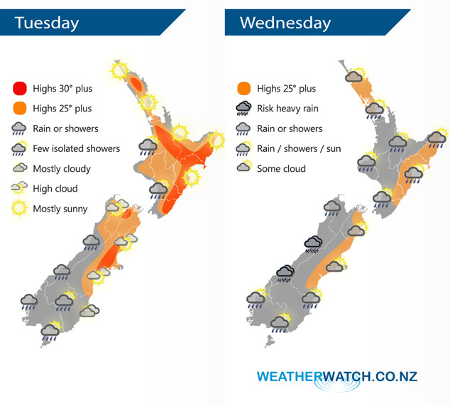
By Weather Analyst Aaron Wilkinson – WeatherWatch.co.nz
Latest Video

Matariki, the long weekend + the outlook for next week
Wet weather and cloud continues along the eastern side of the country with the heaviest rain now moving into northern…
Related Articles
Matariki, the long weekend + the outlook for next week
Wet weather and cloud continues along the eastern side of the country with the heaviest rain now moving into northern…

More eastern rain, but a drier long weekend coming
Rain continues today along the eastern South Island and lower North Island, coming in from the east with heavy falls….

More heavy rain, snow – but large dry areas, especially as we go into the long weekend
Heavy rain will continue for parts of Canterbury and Marlborough over the next day or two and it will gradually…

