InfoGraphic: The Big Picture for Tuesday / Wednesday
11/11/2019 6:00pm

> From the WeatherWatch archives
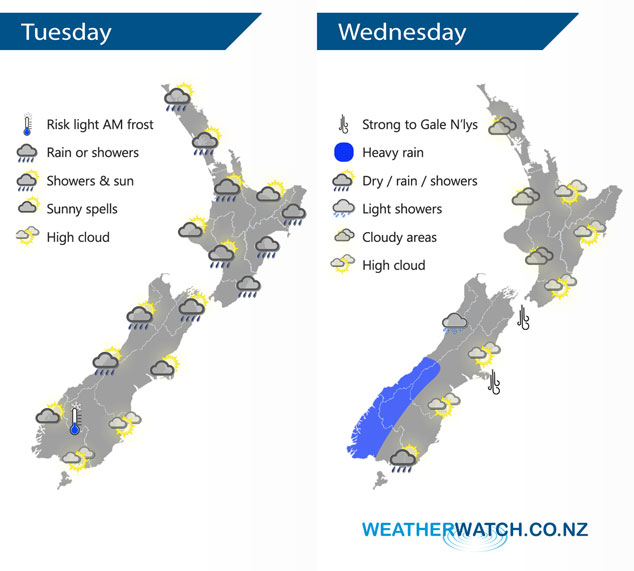
A southwesterly airflow lies over New Zealand today, perhaps becoming a little unstable for the eastern North Island during the afternoon. A northwesterly airflow lies over New Zealand on Wednesday, becoming strong over the South Island. A cold front moves onto the lower South Island from afternoon moving northwards to reach the lower North Island overnight.
A period of rain or showers for the upper North Island today, possibly heavy with thunderstorms and hail then clearing early afternoon. The odd shower becomes heavy along the east coast in the afternoon then clearing later in the evening. The South Island is relatively dry, isolated showers may develop in the afternoon for Marlborough and the odd shower moves into the West Coast during the day north of the Glaciers. Evening showers move in to Fiordland turning to rain there overnight.
A mix of sun and cloud for the western North Island on Wednesday, cloud thicker about Taranaki and Kapiti during the day with the chance of a light shower or two. Rain moves into the southwestern North Island overnight. Mostly sunny with a touch of high cloud for the east coast. Cloudy for the West Coast of the South Island, rain about South Westland becomes heavy from afternoon then pushing northwards in the evening. Expect plenty of high cloud in the east. Rain moves into Southland areas midday then Otago late afternoon or evening with a west to southwest change.
By Weather Analyst Aaron Wilkinson – WeatherWatch.co.nz
Latest Video

Matariki, the long weekend + the outlook for next week
Wet weather and cloud continues along the eastern side of the country with the heaviest rain now moving into northern…
Related Articles
Matariki, the long weekend + the outlook for next week
Wet weather and cloud continues along the eastern side of the country with the heaviest rain now moving into northern…

More eastern rain, but a drier long weekend coming
Rain continues today along the eastern South Island and lower North Island, coming in from the east with heavy falls….

More heavy rain, snow – but large dry areas, especially as we go into the long weekend
Heavy rain will continue for parts of Canterbury and Marlborough over the next day or two and it will gradually…

