InfoGraphic: The Big Picture for Tuesday / Wednesday
16/09/2019 7:28pm

> From the WeatherWatch archives
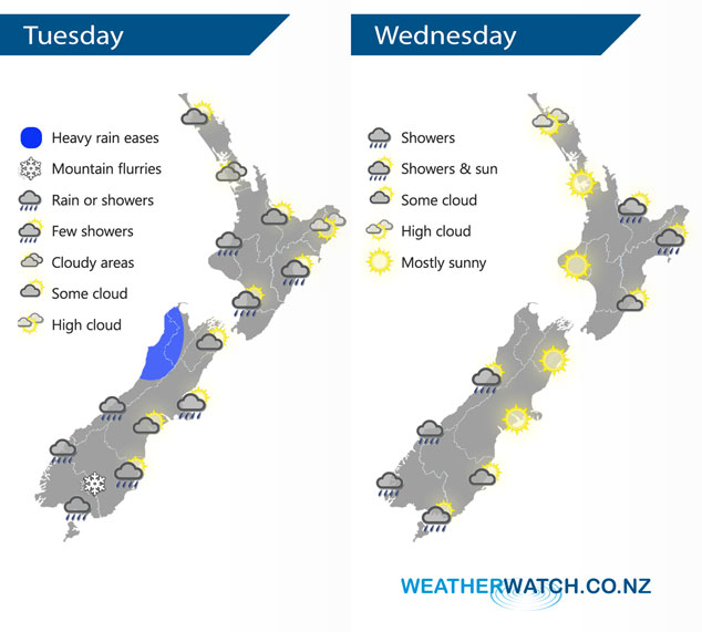
A cold front moves northwards over the North Island today weakening as it goes, a cold southwest airflow lies over the South Island. An anticyclone moves over most of New Zealand on Wednesday coming in from the Tasman Sea.
A band of rain / showers moves northwards over the North Island slowly during Tuesday, not reaching Auckland and Northland till the evening / overnight. Early heavy rain eases about the northwestern corner of the South Island, expect showers for most other South Island regions although Canterbury and Marlborough are mainly dry. Canterbury could see a shower or two from afternoon Banks Peninsula northwards. A few sleety showers are to be expected about Southland with a few snow flurries to 400 or perhaps even 300m at times in a cold westerly airflow.
Most of the North Island is fairly settled on Wednesday, however expect a few morning showers in the east to clear then afternoon sun breaks through, showers may linger about Gisborne till evening. The Bay Of Plenty sees a few light showers develop in the evening. For the South Island, expect a few showers about South Westland, a shower or two makes it a little further northwards at times and into Southland now and then. Mostly sunny conditions elsewhere.
By Weather Analyst Aaron Wilkinson – WeatherWatch.co.nz
Latest Video

Matariki, the long weekend + the outlook for next week
Wet weather and cloud continues along the eastern side of the country with the heaviest rain now moving into northern…
Related Articles
Matariki, the long weekend + the outlook for next week
Wet weather and cloud continues along the eastern side of the country with the heaviest rain now moving into northern…

More eastern rain, but a drier long weekend coming
Rain continues today along the eastern South Island and lower North Island, coming in from the east with heavy falls….

More heavy rain, snow – but large dry areas, especially as we go into the long weekend
Heavy rain will continue for parts of Canterbury and Marlborough over the next day or two and it will gradually…

