InfoGraphic: The Big Picture for Tuesday / Wednesday
8/10/2018 6:00pm

> From the WeatherWatch archives
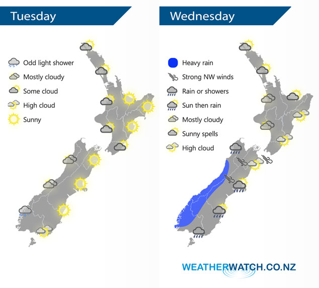
Anticyclonic for much of New Zealand today however there will be a westerly quarter airflow moving over the country. A northwesterly airflow lies over New Zealand on Wednesday, a cold southerly change moves onto the lower South Island early in the morning then pushing northwards during the day.
A mix of sun and cloud for the western side of the North Island today, sunnier conditions out east. A similar story for the South Island although cloud will be thicker in the west with a light shower or two possible at times. Warm afternoon temperatures for eastern New Zealand with temperatures getting into the high teens, perhaps even early twenties for Gisborne.
Cloudy areas for the western North Island on Wednesday, especially about Taranaki southwards where there may be a light shower or two at times. Longer areas of sun Auckland northwards. Mostly sunny for the Bay Of Plenty and along the east coast. Heavy rain slowly pushes northwards along the West Coast of the South Island during the day, a cold southerly change in the east brings rain which reaches North Canterbury in the evening. Snow lowers to 300m in the afternoon for Southland, 500m about Otago in the evening.
By Weather Analyst Aaron Wilkinson – WeatherWatch.co.nz
Latest Video

Matariki, the long weekend + the outlook for next week
Wet weather and cloud continues along the eastern side of the country with the heaviest rain now moving into northern…
Related Articles
Matariki, the long weekend + the outlook for next week
Wet weather and cloud continues along the eastern side of the country with the heaviest rain now moving into northern…

More eastern rain, but a drier long weekend coming
Rain continues today along the eastern South Island and lower North Island, coming in from the east with heavy falls….

More heavy rain, snow – but large dry areas, especially as we go into the long weekend
Heavy rain will continue for parts of Canterbury and Marlborough over the next day or two and it will gradually…

