InfoGraphic: The Big Picture for Tuesday / Wednesday
16/04/2018 7:00pm

> From the WeatherWatch archives
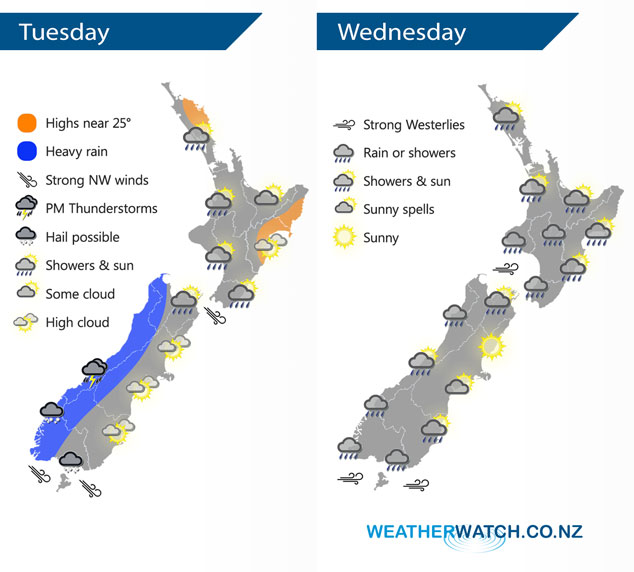
A cold front pushes northwards over the South Island early today then the North Island in the afternoon and evening, meanwhile another cold front lands onto the lower South Island this afternoon.
Bouts of heavy rain can be expected for the West Coast of the South Island this morning then from afternoon a further surge of cold air brings showers with a chance of thunderstorms and hail about the lower South Island, mainly in the west.
Further north a period of showers may become heavy about the western North Island for a time later in the afternoon / evening. Conditions for eastern New Zealand are mainly dry and sunny, overnight a southwest change moves through north Otago and Canterbury (mainly coastal) which could bring heavy showers and hail.
Showers for western New Zealand on Wednesday, Taranaki through to Kapiti could see the odd heavy fall and some small hail in the morning then easing from afternoon. Any morning showers about coastal Canterbury clear. Despite the chance of a shower in the east for other eastern areas like the east coast of the North Island and coastal Otago the majority of the day will be dry with some sun.
By Weather Analyst Aaron Wilkinson – WeatherWatch.co.nz
Latest Video

Wintry change coming for SI and lower NI
Some wet weather, along with a drop in temperatures, will move into the lower South Island later on Sunday and…
Related Articles
Wintry change coming for SI and lower NI
Some wet weather, along with a drop in temperatures, will move into the lower South Island later on Sunday and…

Cold front coming Sunday to Tuesday
High pressure is moving in with more frosts and foggy patches, but on Sunday a nor’wester kicks in with rain…

High pressure moving in + Mystery Creek forecast
The windy weather is clearing NZ over the next 24 hours, to be replaced by frosts and fog patches in…

