
> From the WeatherWatch archives
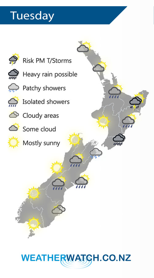
A ridge of high pressure lies over the South Island on Tuesday meanwhile an occluded front to the east curls into a weak area of low pressure over the North Island.
Looking drier for the North Island on Tuesday, the odd isolated shower may creep into Waikato / Bay Of Plenty late afternoon / evening. Rain about Wairarapa may be heavy in the morning then easing, mainly dry for Hawkes Bay / Gsiborne however during the afternoon isolated showers develop about the ranges, some may become heavy with thunderstorms.
Cloud and the odd shower / drizzle patch for eastern parts of the South Island on Tuesday, sunnier conditions out west.
By Weather Analyst Aaron Wilkinson – WeatherWatch.co.nz
Comments
Latest Video

Matariki, the long weekend + the outlook for next week
Wet weather and cloud continues along the eastern side of the country with the heaviest rain now moving into northern…
Related Articles
Matariki, the long weekend + the outlook for next week
Wet weather and cloud continues along the eastern side of the country with the heaviest rain now moving into northern…

More eastern rain, but a drier long weekend coming
Rain continues today along the eastern South Island and lower North Island, coming in from the east with heavy falls….

More heavy rain, snow – but large dry areas, especially as we go into the long weekend
Heavy rain will continue for parts of Canterbury and Marlborough over the next day or two and it will gradually…


Bruce on 30/03/2020 11:10am
Hi there I am in Tauranga and there is an electrical storm of sorts brewing off the coast with pretty exciting lightning display . I also observed what looks like a ring of at least 6 lights spaced fairly evenly around the storm . I’m guessing some sort of satellites ,giving off a flickering red/green light . Any others report seeing this