
> From the WeatherWatch archives
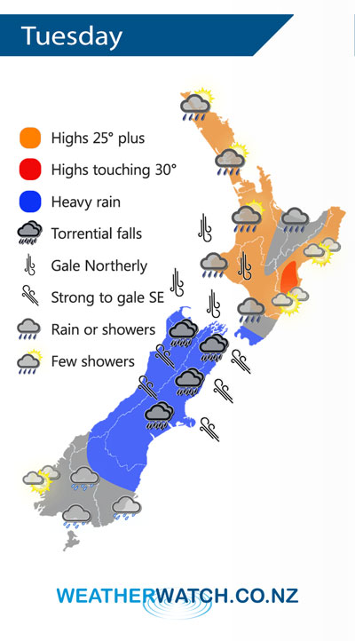
Cyclone Gita approaches fast on Tuesday with its centre moving over the upper South Island overnight.
Gita moves over the upper South Island later in the evening on Tuesday. With this very tightly packed and deep low comes very strong winds and very heavy rain for central parts of the country.
The heaviest and most torrential falls looks to be for the east of the South Island Canterbury northwards and especially about Nelson and Marlborough then easing overnight. Conditions in terms of wind and rain ramps up from afternoon as the low moves in, evening will see the most intense period with this low then easing overnight.
Just a note that very heavy snow is looking likely above 1000m in South and Mid Canterbury afternoon onwards on Tuesday, for northern North Canterbury this level will be above 1400m.
By Weather Analyst Aaron Wilkinson – WeatherWatch.co.nz
Latest Video

Wintry weather coming: Snow, rain, wind & sunshine
A cold front is moving into NZ from Friday to Sunday with low pressure developing west of NZ and then…
Related Articles
Wintry weather coming: Snow, rain, wind & sunshine
A cold front is moving into NZ from Friday to Sunday with low pressure developing west of NZ and then…

ClimateWatch: JULY outlook & what El Niño means for NZ
El Niño is officially here and still getting stronger in the months ahead, but it’s harder to notice its effects…

Low pressure heading to NZ this weekend & into next week
Many regions have settled weather at the moment with frosts as far north as Auckland this morning, but still some…

