InfoGraphic: The Big Picture for Thursday / Friday
13/11/2019 6:00pm

> From the WeatherWatch archives
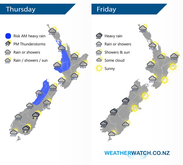
A cold front moves off the North Island away to the northeast this afternoon, meanwhile an area of low pressure moves onto the South Island bringing potentially unstable conditions in the southeast after midday. A westerly airflow lies over New Zealand on Friday, a front within this flow pushes into the southwestern corner of the South Island by midday.
Morning rain with a chance of heavy falls (possible thunderstorms for Northland) in the west for the North Island today then clearing with sunny areas developing, later in the evening showers move back in again. Morning high cloud along the east coast with a few spits of rain then becoming mostly sunny in the afternoon. Early morning heavy rain eases about North Westland to showers, showers elsewhere along the West Coast then rain moves in again during the afternoon. The east coast is largely dry although the odd shower is possible, morning showers about Canterbury then clearing away. During the afternoon showers become heavy with a risk of thunder / hail from eastern Southland through to Banks Peninsula in the east then clearing at night.
The odd shower for the western North Island on Friday (especially morning) then drying out in the afternoon with sunny spells increasing. Sunny weather along the east coast. The odd shower for the West Coast of the South Island, heavy rain pushes into Fiordland by midday then slowly pushes northwards reaching North Westland in the evening. Mainly sunny weather in the east, high cloud increases about Southland and Otago, evening scattered rain for Southland.
By Weather Analyst Aaron Wilkinson – WeatherWatch.co.nz
Latest Video

Matariki, the long weekend + the outlook for next week
Wet weather and cloud continues along the eastern side of the country with the heaviest rain now moving into northern…
Related Articles
Matariki, the long weekend + the outlook for next week
Wet weather and cloud continues along the eastern side of the country with the heaviest rain now moving into northern…

More eastern rain, but a drier long weekend coming
Rain continues today along the eastern South Island and lower North Island, coming in from the east with heavy falls….

More heavy rain, snow – but large dry areas, especially as we go into the long weekend
Heavy rain will continue for parts of Canterbury and Marlborough over the next day or two and it will gradually…

