InfoGraphic: The Big Picture for Thursday / Friday
31/07/2019 7:00pm

> From the WeatherWatch archives
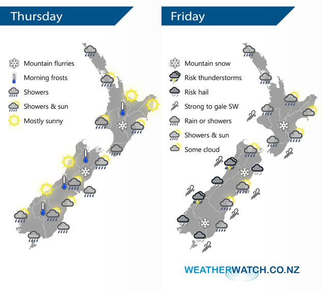
Cold southwesterlies lie over both the South and North Islands today. A low pressure system south of New Zealand flicks a cold front and associated very cold air over New Zealand on Friday.
Showers about Northland ease this evening, morning showers for Auckland then sunny spells develop. Showers for Taranaki in the west down to Wellington then up the east coast through to about Mahia Peninsula, shower activity most intense for Wellington and Wairarapa. Snow flurries to 500m about the Central Plateau. A sunny day for the West Coast of the South Island and Nelson / Marlborough. The interior of the eastern South Island may see a few early showers then dry with sunny spells, North Canterbury and Banks Peninsula sees showers gradually ease then mostly clearing in the evening, snow flurries to 400m and lifting during the day. A few showers pepper the far south for most of the day, snow flurries stick above 500 to 600m.
Showers for the western North Island on Friday, picking up in intensity from afternoon, blustery west to southwesterly winds. The east coast is mainly dry with some high cloud, in the afternoon a few spots of rain may spread from the west. Wellington has a dry morning, afternoon showers then dry again evening, strong to gale WNW winds. Rain with heavy falls and possible thunderstorms / hail along the West Coast, easing in the evening. Snow in the ranges to 500m. Nelson sees showers at times from midday, Marlborough is mostly sunny, blustery westerlies. Sunny areas for Canterbury with northwesterly winds, tending southwest in the evening near the coast, the odd shower possible about Banks Peninsula then overnight showers pick up for coastal areas. Showers or spots of rain about the far south turning to rain in the afternoon as northwesterlies change strong to gale southwest. Rain may be heavy then easing overnight, snow to 500m.
By Weather Analyst Aaron Wilkinson – WeatherWatch.co.nz
Latest Video

Matariki, the long weekend + the outlook for next week
Wet weather and cloud continues along the eastern side of the country with the heaviest rain now moving into northern…
Related Articles
Matariki, the long weekend + the outlook for next week
Wet weather and cloud continues along the eastern side of the country with the heaviest rain now moving into northern…

More eastern rain, but a drier long weekend coming
Rain continues today along the eastern South Island and lower North Island, coming in from the east with heavy falls….

More heavy rain, snow – but large dry areas, especially as we go into the long weekend
Heavy rain will continue for parts of Canterbury and Marlborough over the next day or two and it will gradually…

