InfoGraphic: The Big Picture for Thursday / Friday
15/08/2018 7:00pm

> From the WeatherWatch archives
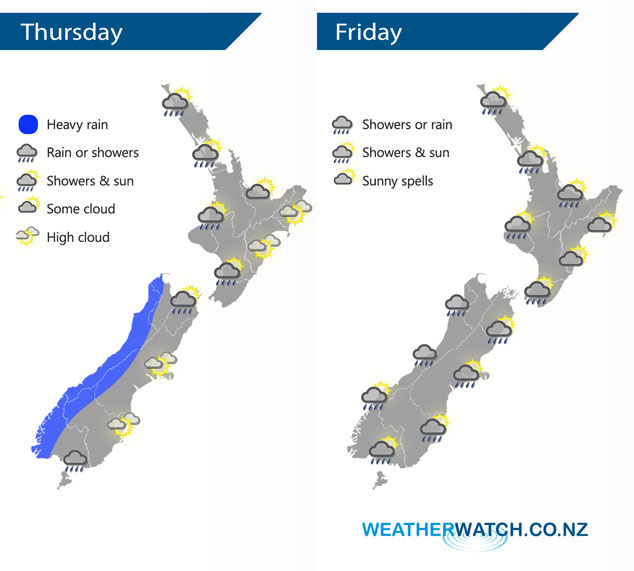
A northwesterly airflow lies over New Zealand today. A cold southwesterly airflow develops on Friday, a front within this flow clears the North Island in the morning then another region of activity builds over the South Island from afternoon.
Some cloud and the chance of a shower for the western North Island today, becoming more persistent later in the day. Dry and mainly sunny in the east with warm temperatures. For the South Island some heavy rain pushes northwards along the West Coast during the day. Mainly dry in the east with some high cloud although a few showers affect Southland and perhaps Otago, especially afternoon.
Morning showers for the western North Island may be heavy with hail and possible thunderstorms then easing with some sun breaking through by midday, winds from the west. Sunny areas and some cloud in the east. Showers for the West Coast of the South Island clears overnight, elsewhere over the South Island expect sunny spells and the chance of an isolated shower. Showers becoming more widespread during the afternoon, there may even be the odd isolated heavy fall with some hail then easing overnight for Southland / Otago.
By Weather Analyst Aaron Wilkinson – WeatherWatch.co.nz
Latest Video

Matariki, the long weekend + the outlook for next week
Wet weather and cloud continues along the eastern side of the country with the heaviest rain now moving into northern…
Related Articles
Matariki, the long weekend + the outlook for next week
Wet weather and cloud continues along the eastern side of the country with the heaviest rain now moving into northern…

More eastern rain, but a drier long weekend coming
Rain continues today along the eastern South Island and lower North Island, coming in from the east with heavy falls….

More heavy rain, snow – but large dry areas, especially as we go into the long weekend
Heavy rain will continue for parts of Canterbury and Marlborough over the next day or two and it will gradually…

