InfoGraphic: The Big Picture for Thursday / Friday
1/08/2018 7:00pm

> From the WeatherWatch archives
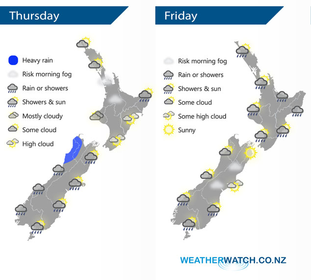
A low pressure system just west of the South Island today slowly rotates a front onto the West Coast of the South Island this afternoon then the west of the North Island overnight. A broad but weak low pressure system lies over New Zealand on Friday, a front associated with this low gradually moves from west to east over the North Island during the day.
Sunny areas and thickening cloud for much of the North Island today, a few showers may move in from the west this evening then rain pushes in overnight. Mainly dry in the east, showers linger about East Cape for much of the day. Rain for the West Coast of the South Island eases in the evening. Thick high cloud in the east with a few spots of rain at times, more so later this afternoon / evening.
Rain eases for most of the western North Island on Friday morning to the odd shower, some sun may break through also. Rain about the Bay Of Plenty eases from afternoon, sun may not make an appearance till later in the day. Some rain for the Wairarapa spreads into Hawkes Bay during the morning then into Gisborne early afternoon. Mainly dry for the South Island with a chance of morning fog for some inland areas, especially Canterbury. The odd shower about also, especially the southern half of the Island.
By Weather Analyst Aaron Wilkinson – WeatherWatch.co.nz
Latest Video

Matariki, the long weekend + the outlook for next week
Wet weather and cloud continues along the eastern side of the country with the heaviest rain now moving into northern…
Related Articles
Matariki, the long weekend + the outlook for next week
Wet weather and cloud continues along the eastern side of the country with the heaviest rain now moving into northern…

More eastern rain, but a drier long weekend coming
Rain continues today along the eastern South Island and lower North Island, coming in from the east with heavy falls….

More heavy rain, snow – but large dry areas, especially as we go into the long weekend
Heavy rain will continue for parts of Canterbury and Marlborough over the next day or two and it will gradually…

