
> From the WeatherWatch archives
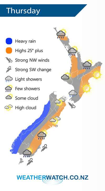
A northwesterly airflow lies over New Zealand on Thursday with a cold front pushing onto the lower South Island around midday, reaching the top of the South Island just after midnight.
Mostly sunny to start for the upper North Island on Thursday, a few isolated showers may push in during the afternoon however from Northland through to Bay Of Plenty. Mainly sunny in the east, some cloud in the west with the chance of a light shower or two about Kapiti.
Heavy rain pushes northwards along the West Coast of the South Island from afternoon, dry and warm in the east however a cold southwest change pushes into Southland and Otago during the afternoon reaching Banks Peninsula in the evening bringing rain or showers.
By Weather Analyst Aaron Wilkinson – WeatherWatch.co.nz
Latest Video

Matariki, the long weekend + the outlook for next week
Wet weather and cloud continues along the eastern side of the country with the heaviest rain now moving into northern…
Related Articles
Matariki, the long weekend + the outlook for next week
Wet weather and cloud continues along the eastern side of the country with the heaviest rain now moving into northern…

More eastern rain, but a drier long weekend coming
Rain continues today along the eastern South Island and lower North Island, coming in from the east with heavy falls….

More heavy rain, snow – but large dry areas, especially as we go into the long weekend
Heavy rain will continue for parts of Canterbury and Marlborough over the next day or two and it will gradually…

