
> From the WeatherWatch archives
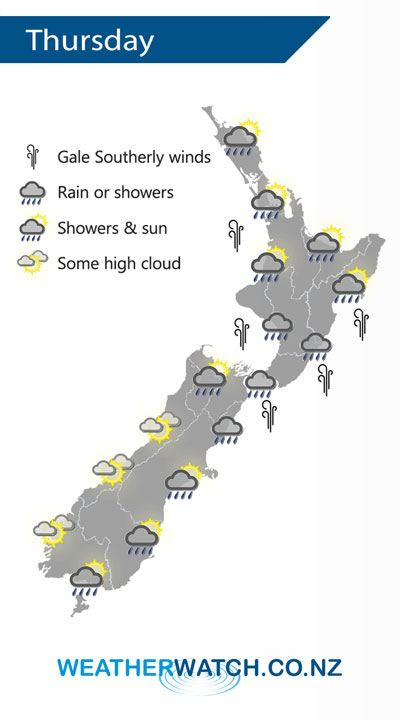
A large high sits in the Tasman Sea on Thursday directing a southwesterly airflow over New Zealand, a warm front pushes northwards over the country during the day.
A shower or two for the upper North Island on Thursday, many long dry areas also especially in the east. Showers more prevalent for the lower North Island, a period of rain moves through around midday then eases in the evening. Rain may not move into Hawkes Bay and Gisborne till evening. Some snow about the Central Plateau down to 500m for a time.
Southerlies about the lower North Island build from afternoon, rising to gale about some coastal areas.
Mostly sunny along the West Coast of the South Island, just some high cloud. In the east expect a period of rain to push northwards during the morning for Canterbury and Marlborough then easing late afternoon, just a shower or two expected about Southland and Otago.
By Weather Analyst Aaron Wilkinson – WeatherWatch.co.nz
Latest Video

ClimateWatch: JULY outlook & what El Niño means for NZ
El Niño is officially here and still getting stronger in the months ahead, but it’s harder to notice its effects…
Related Articles
ClimateWatch: JULY outlook & what El Niño means for NZ
El Niño is officially here and still getting stronger in the months ahead, but it’s harder to notice its effects…

Low pressure heading to NZ this weekend & into next week
Many regions have settled weather at the moment with frosts as far north as Auckland this morning, but still some…

Colder nights/mornings, polar change coming Sun/Mon
The nights and mornings ahead will be colder in a number of regions – but an even colder change is…

