InfoGraphic: The Big Picture for Saturday / Sunday
4/10/2019 2:00am

> From the WeatherWatch archives
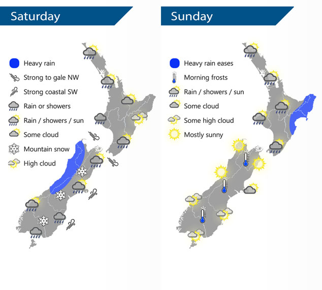
A cold front pushes northwards over New Zealand during Saturday, northwesterlies ahead of the front then changing colder southwest in behind. A ridge of high pressure pushes on to the country on Sunday bringing clearing conditions.
Cloudy areas and the odd shower for the western North Island on Saturday, rain moves into the lower western North Island from afternoon then further north later in the evening. Mostly sunny in the east, rain moves into Wellington / Wairarapa in the afternoon then further north in the evening. Heavy rain for the West Coast of the South Island clears in the afternoon. Early rain eases to showers about Southland / Otago, a few snow flurries may make it down to 200m before clearing in the evening. Morning rain develops for Canterbury, easing to showers by midday then clearing at night, some snow down to 300m before clearing. Nelson and Marlborough has a period of afternoon rain, clearing in the evening.
Showers for most of the North Island clear on Sunday morning, a few linger about Northland into the afternoon however. Morning heavy rain for the east coast eases then clears. The South Island has mainly settled weather, some morning cloud about Banks Peninsula gradually clears away. Some high cloud develops about the lower half of the Island from afternoon.
By Weather Analyst Aaron Wilkinson – WeatherWatch.co.nz
Latest Video

Matariki, the long weekend + the outlook for next week
Wet weather and cloud continues along the eastern side of the country with the heaviest rain now moving into northern…
Related Articles
Matariki, the long weekend + the outlook for next week
Wet weather and cloud continues along the eastern side of the country with the heaviest rain now moving into northern…

More eastern rain, but a drier long weekend coming
Rain continues today along the eastern South Island and lower North Island, coming in from the east with heavy falls….

More heavy rain, snow – but large dry areas, especially as we go into the long weekend
Heavy rain will continue for parts of Canterbury and Marlborough over the next day or two and it will gradually…

