InfoGraphic: The Big Picture for Saturday / Sunday
9/08/2019 2:46am

> From the WeatherWatch archives
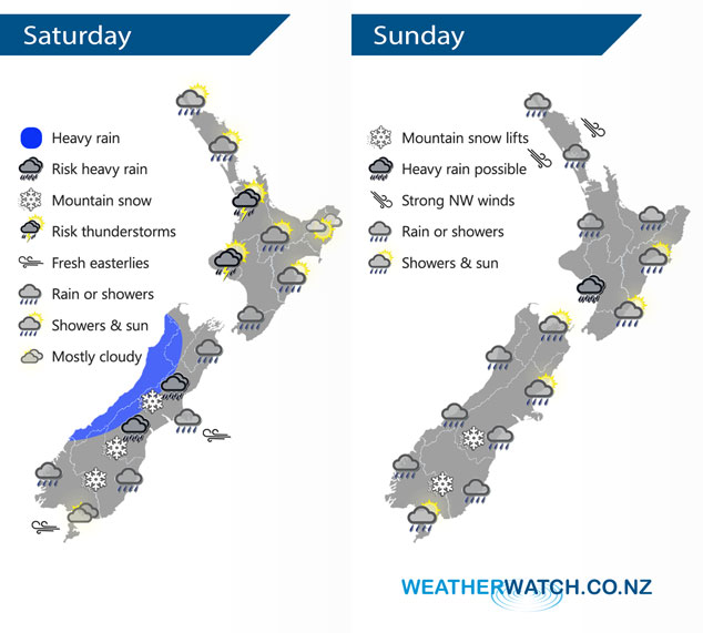
Rain for much of the South Island on Saturday with easterlies, snow possible to low levels for some. Northwesterlies further north. Northwesterlies continue for the North Island on Sunday, low pressure further south.
Showers for much of the western North Island and Wairarapa on Saturday, showers may be heavy with thunderstorms about Taranaki and Waikato. Hawkes Bay and Gisborne are mainly dry with some high cloud. Rain for much of the South Island, heavy at times along the West Coast, possibly heavy for inland Canterbury. Snow to 800m about North Canterbury then lowering to about 300 or possibly 200m for Otago. Heavy snow possible for inland parts of Canterbury especially Banks Peninsula southwards and North Otago.
Gusty northwesterlies cover much of the North Island on Sunday, expect showers with the odd isolated heavy fall possible especially in the west. The east coast is drier however spots of rain spread from the west at times. Wet for the West Coast of the South Island and also many in the east however Banks Peninsula northwards in the east morning showers clear then some sun breaks through. Snow flurries to 500m about the far south then lifting during the day.
By Weather Analyst Aaron Wilkinson – WeatherWatch.co.nz
Latest Video

Matariki, the long weekend + the outlook for next week
Wet weather and cloud continues along the eastern side of the country with the heaviest rain now moving into northern…
Related Articles
Matariki, the long weekend + the outlook for next week
Wet weather and cloud continues along the eastern side of the country with the heaviest rain now moving into northern…

More eastern rain, but a drier long weekend coming
Rain continues today along the eastern South Island and lower North Island, coming in from the east with heavy falls….

More heavy rain, snow – but large dry areas, especially as we go into the long weekend
Heavy rain will continue for parts of Canterbury and Marlborough over the next day or two and it will gradually…

