InfoGraphic: The Big Picture for Saturday / Sunday
19/07/2019 9:18pm

> From the WeatherWatch archives
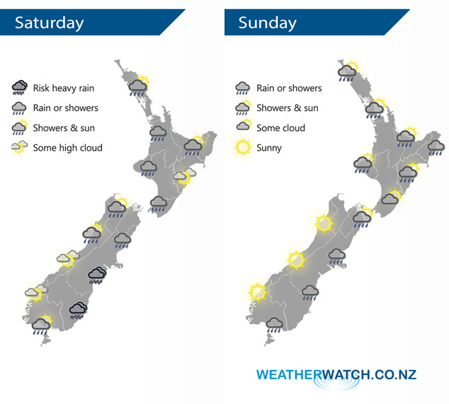
A low is centred to the east of New Zealand on Saturday driving an easterly airflow over the South Island, westerlies further north. The low starts to weaken on Sunday but still has some sting in its tail with further rain lined up for the eastern South Island, possibly heavy.
Showers for much of Saturday about the western North Island, drier in the east. A wet day for the eastern South Island with areas of rain or showers, heavy falls possible from evening / overnight. Mainly dry for the west coast however expect a few showers north of about Hokitika especially in the morning.
A fair majority of the North Island is looking fairly dry on Sunday in the very latest model updates that have come through since the maps below were drawn. Still…. Northland, Taranaki and Wellington look to see some rain or showers. The eastern South Island sees rain with heavy falls about the Southern Alps / inland ranges, snow will likely be heavy high up also which bodes well for the ski fields. The Central Otago ski fields not as lucky though on Sunday. Conditions are mainly sunny out west.
By Weather Analyst Aaron Wilkinson – WeatherWatch.co.nz
Comments
Latest Video

Matariki, the long weekend + the outlook for next week
Wet weather and cloud continues along the eastern side of the country with the heaviest rain now moving into northern…
Related Articles
Matariki, the long weekend + the outlook for next week
Wet weather and cloud continues along the eastern side of the country with the heaviest rain now moving into northern…

More eastern rain, but a drier long weekend coming
Rain continues today along the eastern South Island and lower North Island, coming in from the east with heavy falls….

More heavy rain, snow – but large dry areas, especially as we go into the long weekend
Heavy rain will continue for parts of Canterbury and Marlborough over the next day or two and it will gradually…


Guest on 19/07/2019 4:52am
its not that warm all kikuya grass has been blatted by frosts any way after such a dry summer and autum you need a break don’t you and that’s the good thing about a wet winter it keeps the frosts away…..a dry winter is pure hell