InfoGraphic: The Big Picture for Saturday / Sunday
7/06/2019 3:00am

> From the WeatherWatch archives
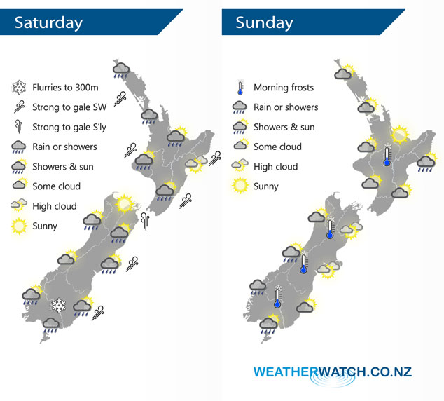
A cold southwesterly airflow lies over the country on Saturday, easing for a time on Sunday however a northwest airflow starts to build from afternoon over the South Island.
Showers affect most North Island regions on Saturday. Dry for much of the day about Hawkes Bay and Gisborne then a few showers move through late afternoon and evening as southwesterlies strengthen. Morning showers for the South Island’s West Coast then sun increasing with cool southwesterly winds, Nelson and Marlborough have a mainly dry day. Mainly dry for Canterbury however a few showers for coastal areas and North Canterbury can be expected for a time in the afternoon as southwesterlies freshen. Showers about Southland and Otago ease during the day, clearing in the evening or overnight.
A frosty start for some on Sunday especially inland. Some cloud at times for the western North Island, sunnier out east although a few morning showers about Gisborne clear. Dry to start for the West Coast of the South Island, some cloud builds from afternoon bringing in a light shower or two. Dry for the eastern South Island with some high cloud, mainly dry for Southland with showers later in the evening or overnight.
By Weather Analyst Aaron Wilkinson – WeatherWatch.co.nz
Latest Video

Matariki, the long weekend + the outlook for next week
Wet weather and cloud continues along the eastern side of the country with the heaviest rain now moving into northern…
Related Articles
Matariki, the long weekend + the outlook for next week
Wet weather and cloud continues along the eastern side of the country with the heaviest rain now moving into northern…

More eastern rain, but a drier long weekend coming
Rain continues today along the eastern South Island and lower North Island, coming in from the east with heavy falls….

More heavy rain, snow – but large dry areas, especially as we go into the long weekend
Heavy rain will continue for parts of Canterbury and Marlborough over the next day or two and it will gradually…

