InfoGraphic: The Big Picture for Saturday / Sunday
31/05/2019 7:56pm

> From the WeatherWatch archives
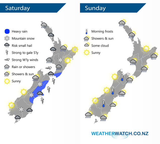
Cold south to southwest winds lies over the South Island on Saturday, spreading onto the North Island overnight. Cold southwesterlies ease over the country on Sunday.
Showers, some possibly heavy with a risk of small hail and thunder for the western North Island on Saturday. Snow flurries affect higher parts of the Central Plateau / Desert Road. Expect strong southerlies in the east from Canterbury through to Wellington, heavy rain about Canterbury in the morning then easing to showers. The odd shower and risk of small hail from Southland up through to Canterbury, showers about North Westland / Buller clear in the afternoon.
Flurries getting down to 300m about the lower South Island for a time on Saturday, 400m in Canterbury, 800m about the Central Plateau.
Showers becoming restricted mostly to southwern and eastern parts of New Zealand on Sunday, clearing away from inland areas. Auckland northwards has morning showers which clear then sunny spells increase. Sunny weather for the West Coast of the South Island, Nelson and the Bay Of Plenty.
By Weather Analyst Aaron Wilkinson – WeatherWatch.co.nz
Latest Video

Slow moving low to track over northern NZ
A low pressure zone will slowly cross the North Island over the coming days, bringing hit and miss pockets of…
Related Articles
Slow moving low to track over northern NZ
A low pressure zone will slowly cross the North Island over the coming days, bringing hit and miss pockets of…

NI low pressure, SI polar change
Low pressure will move over the upper North Island this week, bringing hit and miss pockets of heavier rain into…

Rain & showers this weekend, colder change next week
Some places will warm up over the next day or so as a nor’wester out of Australia moves across NZ,…

