InfoGraphic: The Big Picture for Saturday / Sunday
17/05/2019 7:44pm

> From the WeatherWatch archives
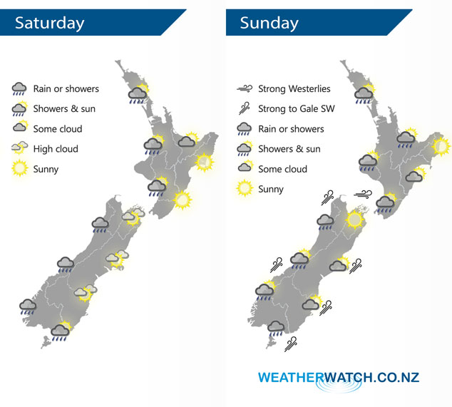
A westerly airflow lies over the country on Saturday, a cold front within this flow pushes northwards over the South Island during the second half of the day. The flow tilts more southwest on Sunday with strong winds skirting some coastal areas but on land itself not so bad.
Areas of cloud and the odd shower at times for the western North Island on Saturday, showers more likely from afternoon. A mix of sun and cloud for the Bay Of Plenty, sunny for the east coast (Gisborne to Wairarapa). Rain or showers for the South Island’s West Coast during the day, showers at times for Southland also and a spot or two may make it into Otago at times. Mostly sunny with some high cloud from Canterbury through to Nelson.
A shower or two for most North Island regions on Sunday, dry till late afternoon / evening about Hawkes Bay and Gisborne when a few showers finally make their way in. Morning showers clear along the West Coast of the South Island, perhaps not clearing Buller till evening. Generally dry elsewhere apart from Southland which sees showers for much of the day.
By Weather Analyst Aaron Wilkinson – WeatherWatch.co.nz
Latest Video

Matariki, the long weekend + the outlook for next week
Wet weather and cloud continues along the eastern side of the country with the heaviest rain now moving into northern…
Related Articles
Matariki, the long weekend + the outlook for next week
Wet weather and cloud continues along the eastern side of the country with the heaviest rain now moving into northern…

More eastern rain, but a drier long weekend coming
Rain continues today along the eastern South Island and lower North Island, coming in from the east with heavy falls….

More heavy rain, snow – but large dry areas, especially as we go into the long weekend
Heavy rain will continue for parts of Canterbury and Marlborough over the next day or two and it will gradually…

