InfoGraphic: The Big Picture for Monday / Tuesday
18/08/2019 7:00pm

> From the WeatherWatch archives
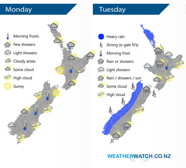
A ridge of high pressure lies over New Zealand this morning extending out from an anticyclone to the east, as the day moves along the ridge loses its grip and a northwesterly airflow builds over the South Island. Strong northerlies lie over the country on Tuesday with a front pushing into the lower South Island in the morning, reaching the western North Island in the evening.
Some cloud for Northland today, also Coromandel and perhaps western Bay Of Plenty. Risk of a shower about some exposed areas like eastern Northland, Great Barrier Island and the Coromandel. Risk of a shower about East Cape also. Cloud about Hawkes Bay slowly breaks from afternoon, morning cloud about the Wairarapa then mostly sunny. Cloud gradually increases along the South Island’s West Coast, light showers about Fiordland spread northwards in the evening. Mostly sunny with developing high cloud out east.
Heavy rain spreads northwards along the West Coast of the South Island on Tuesday, reaching Northland in the evening. Generally drier conditions in the east with some high cloud. A period of rain or showers working there way into Southland and Otago however.
By Weather Analyst Aaron Wilkinson – WeatherWatch.co.nz
Latest Video

Matariki, the long weekend + the outlook for next week
Wet weather and cloud continues along the eastern side of the country with the heaviest rain now moving into northern…
Related Articles
Matariki, the long weekend + the outlook for next week
Wet weather and cloud continues along the eastern side of the country with the heaviest rain now moving into northern…

More eastern rain, but a drier long weekend coming
Rain continues today along the eastern South Island and lower North Island, coming in from the east with heavy falls….

More heavy rain, snow – but large dry areas, especially as we go into the long weekend
Heavy rain will continue for parts of Canterbury and Marlborough over the next day or two and it will gradually…

