InfoGraphic: The Big Picture for Friday / Saturday
27/02/2020 6:00pm

> From the WeatherWatch archives
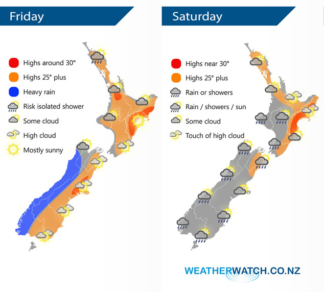
A ridge brings mainly settled weather to the North Island today meanwhile frontal activity brings heavy rain to the West Coast of the South Island and dry weather out east. This front moves off the upper South Island and onto the lower North Island on Saturday morning, it will weaken quickly as it does then a ridge of high pressure pushes in from the Tasman Sea.
Mainly settled for the North Island today, some cloud at times mainly afternoon / evening. Risk of an isolated shower for Northland late afternoon / evening. Rain for the West Coast of the South Island is heavy at times, finally pushing northwards in the evening. Mainly dry in the east with some high cloud. Later in the evening / overnight some rain moves into Southland then a few showers for Otago with a southwest change.
Mainly dry for the northeast of the North Island on Saturday, some rain moves into the southwest during the morning then quickly easing to showers and mostly clearing away in the afternoon. A shower or two may linger into the evening for some. Showers activity for most South Island regions clears away by afternoon with sunny areas increasing, winds from the southwest east tending easterly in the afternoon for the east coast.
By Weather Analyst Aaron Wilkinson – WeatherWatch.co.nz
Comments
Latest Video

Matariki, the long weekend + the outlook for next week
Wet weather and cloud continues along the eastern side of the country with the heaviest rain now moving into northern…
Related Articles
Matariki, the long weekend + the outlook for next week
Wet weather and cloud continues along the eastern side of the country with the heaviest rain now moving into northern…

More eastern rain, but a drier long weekend coming
Rain continues today along the eastern South Island and lower North Island, coming in from the east with heavy falls….

More heavy rain, snow – but large dry areas, especially as we go into the long weekend
Heavy rain will continue for parts of Canterbury and Marlborough over the next day or two and it will gradually…


Guest on 27/02/2020 7:11pm
its starting to look like two failed tropical seasons in a row for the north island