InfoGraphic: The Big Picture for Friday / Saturday
5/09/2019 8:09pm

> From the WeatherWatch archives
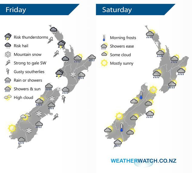
Cold southwesterlies cover the country today, easing on Saturday.
Rain or showers for most of the North Island today, from afternoon showers becoming heavy in areas with a risk of hail / thunder for the upper North Island especially out west. Snow flurries about the Central Plateau lower to 800m later in the day. Rain or showers for much of the eastern South Island from Southland up through to Nelson, easing from afternoon. Morning showers about North Westland clear then expect high cloud, showers may hang about Buller through till evening. Mostly sunny about South Westland. Snow flurries to 500m about Southland / Otago, 600m for Canterbury, a few may make it below this level by a couple hundred meters later in the day but amounts will be minimal and will taper away.
Showers for the upper and western North Island ease during the day with sunny spells gradually increasing, southwesterlies ease in the evening. Morning showers clear on the east coast then sunny areas increase. The South Island has a few showers around the edges otherwise expect areas of cloud to break to some sun as the day moves along. A frosty start about Central Otago and inland Buller.
By Weather Analyst Aaron Wilkinson – WeatherWatch.co.nz
Latest Video

Matariki, the long weekend + the outlook for next week
Wet weather and cloud continues along the eastern side of the country with the heaviest rain now moving into northern…
Related Articles
Matariki, the long weekend + the outlook for next week
Wet weather and cloud continues along the eastern side of the country with the heaviest rain now moving into northern…

More eastern rain, but a drier long weekend coming
Rain continues today along the eastern South Island and lower North Island, coming in from the east with heavy falls….

More heavy rain, snow – but large dry areas, especially as we go into the long weekend
Heavy rain will continue for parts of Canterbury and Marlborough over the next day or two and it will gradually…

