InfoGraphic: The Big Picture for Friday / Saturday
15/08/2019 7:00pm

> From the WeatherWatch archives
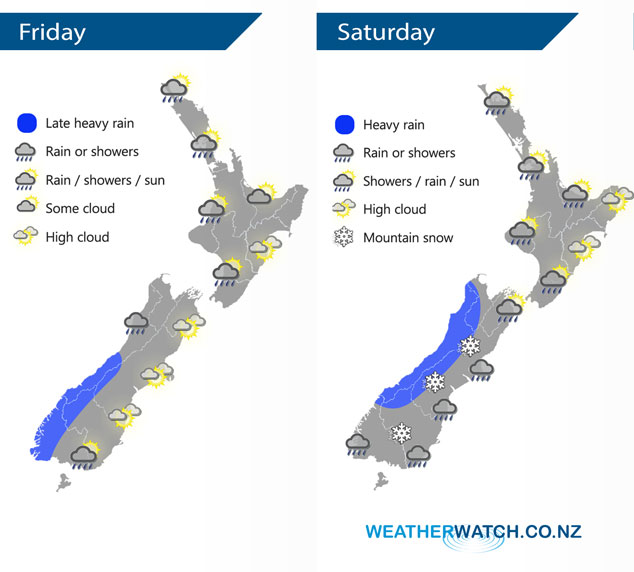
A west to northwesterly airflow lies over New Zealand today. Cold southerlies push northwards over the South Island on Saturday reaching the lower North Island in the afternoon.
Cloudy areas and the odd shower for the western North Island today, drier and sunnier out east. Rain for the West Coast of the South Island, possibly heavy from afternoon, likely to be heavy overnight. Drier out east with some high cloud and warm temperatures, showers spread into Southland in the afternoon then Otago in the evening.
Showers for much of the upper North Island on Saturday, especially in the west. Rain from afternoon for Taranaki through to Wellington. Rain develops about Wairarapa around midday spreading further northwards in the evening with cold southerlies. Snow lowers to 400m at night about the lower North Island. Heavy morning rain for the South Island’s West Coast then easing and sun breaks through from afternoon. Rain about Nelson, Marlborough and Canterbury (possibly heavy inland) then easing from late afternoon, snow lowers to 300 or possibly 200m by evening. Cloudy areas and the odd shower about Southland and Otago, cold southerlies with a few snow flurries possibly as low as 100m.
By Weather Analyst Aaron Wilkinson – WeatherWatch.co.nz
Latest Video

Matariki, the long weekend + the outlook for next week
Wet weather and cloud continues along the eastern side of the country with the heaviest rain now moving into northern…
Related Articles
Matariki, the long weekend + the outlook for next week
Wet weather and cloud continues along the eastern side of the country with the heaviest rain now moving into northern…

More eastern rain, but a drier long weekend coming
Rain continues today along the eastern South Island and lower North Island, coming in from the east with heavy falls….

More heavy rain, snow – but large dry areas, especially as we go into the long weekend
Heavy rain will continue for parts of Canterbury and Marlborough over the next day or two and it will gradually…

