InfoGraphic: The Big Picture for Friday / Saturday
13/06/2019 7:00pm

> From the WeatherWatch archives
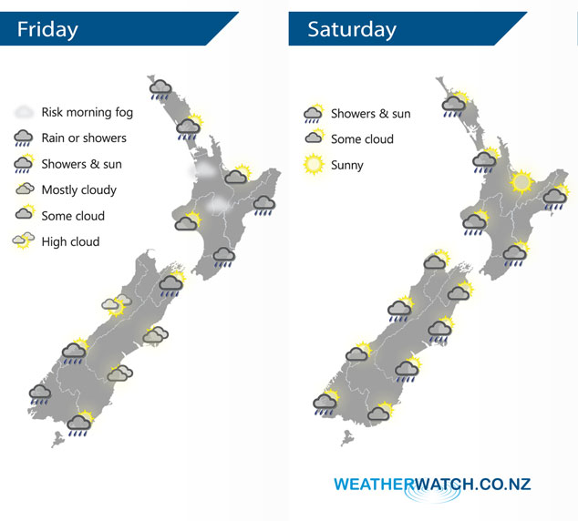
A weakening ridge of high pressure lies over the South Island today, southerlies for the North Island. A front moves onto the lower South Island from afternoon. A southwesterly airflow lies over the country on Saturday.
Rain or showers for the eastern North Island today, sunny spells out west although showers move into Northland / northern Auckland at times. Showers ease about Marlborough clearing in the afternoon for the most part although a light shower may linger till evening. Rain moves into Fiordland by midday then pushes a little further north in the evening and overnight. Some rain moves into Southland during the afternoon then Otago in the evening with the passage of a front.
Showery conditions for most North Island regions on Saturday, the Bay Of Plenty escapes most of the wet weather. Showers for most upper South Island regions clear in the morning then some sun breaking through from afternoon. The odd shower lingers for much of the day about North Westland, rain moves into Fiordland later in the evening / overnight. Any early showers clear coastal Otago then some sun breaks through, morning cloud about Southland and Central Otago breaks to some sun. Overnight rain moves onto the lower South Island as a front pushes in from the southwest.
By Weather Analyst Aaron Wilkinson – WeatherWatch.co.nz
Latest Video

Matariki, the long weekend + the outlook for next week
Wet weather and cloud continues along the eastern side of the country with the heaviest rain now moving into northern…
Related Articles
Matariki, the long weekend + the outlook for next week
Wet weather and cloud continues along the eastern side of the country with the heaviest rain now moving into northern…

More eastern rain, but a drier long weekend coming
Rain continues today along the eastern South Island and lower North Island, coming in from the east with heavy falls….

More heavy rain, snow – but large dry areas, especially as we go into the long weekend
Heavy rain will continue for parts of Canterbury and Marlborough over the next day or two and it will gradually…

