InfoGraphic: The Big Picture for Friday / Saturday
14/02/2019 6:00pm

> From the WeatherWatch archives
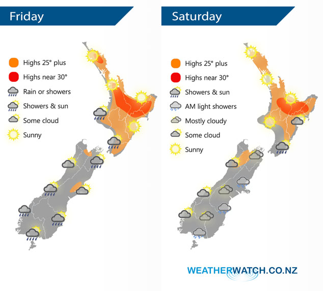
A weak front moves over the North Island today, meanwhile another front lines up the lower South Island. A period of settled weather for regions between the fronts. A ridge pushes over New Zealand on Saturday, extending out from an anticyclone in the Tasman Sea.
Mostly sunny for the upper North Island today, later in the evening some cloud and the risk of a shower moves in from Northland down through to the Waikato. A few morning showers from Taranaki through to Kapiti then sunny areas break through from afternoon. Sunny along the east coast although a shower or two is likely in the afternoon for Wairarapa. Any early showers clear the upper South Island then conditions brighten up, Marlborough may see cloud hang around for the majority of the day however. Some rain moves through Southland in the afternoon then Otago in the evening. Rain moves into Fiordland during the afternoon then pushes northwards reaching North Westland later in the evening.
Mostly sunny for the western North Island on Saturday, southerlies pick up in the east bringing some increasing cloud, chance of a shower about Wairarapa. Mostly cloudy for the South Islands east coast, there may be a shower or drizzle patch, mainly morning. Cloud starts to break late afternoon or evening. Any morning cloud clears along the West Coast then mostly sunny.
By Weather Analyst Aaron Wilkinson – WeatherWatch.co.nz
Latest Video

Matariki, the long weekend + the outlook for next week
Wet weather and cloud continues along the eastern side of the country with the heaviest rain now moving into northern…
Related Articles
Matariki, the long weekend + the outlook for next week
Wet weather and cloud continues along the eastern side of the country with the heaviest rain now moving into northern…

More eastern rain, but a drier long weekend coming
Rain continues today along the eastern South Island and lower North Island, coming in from the east with heavy falls….

More heavy rain, snow – but large dry areas, especially as we go into the long weekend
Heavy rain will continue for parts of Canterbury and Marlborough over the next day or two and it will gradually…

