InfoGraphic: The Big Picture for Friday / Saturday
15/11/2018 6:00pm

> From the WeatherWatch archives
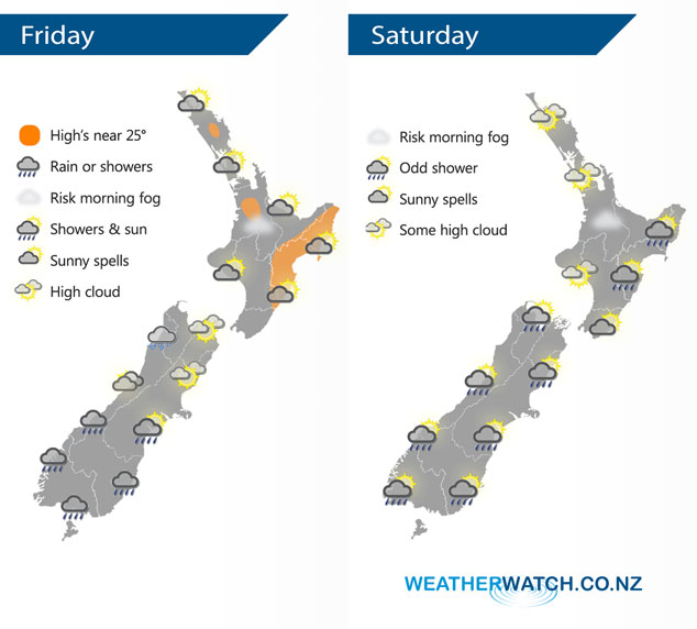
Dry for most of New Zealand today however a front brings some rain to the lower South Island and showers to the upper West Coast of the South Island. Mostly anticyclonic for the North Island on Saturday bringing mainly settled conditions, a slight area of low pressure and a weak frontal zone bring a few showers or some rain to some South Island regions.
Any morning low cloud or fog breaks about the upper North Island today then mostly sunny, mostly sunny elsewhere for the rest of the North Island although Wellington sees cloudy areas. For the South Island we have sunny areas and some high cloud for the upper half, in the evening a few showers gradually push northwards through Canterbury. Some rain for the lower South Island with cool south to southeast winds.
Mostly sunny weather for the North Island on Saturday, some high cloud can be expected. Isolated showers about the ranges of Hawkes Bay / Gisborne from afternoon, some could be heavy with a risk of thunder then easing in the evening. Morning cloud about Kapiti may bring some drizzle, Wellington sees cloudy areas for much of the day. Most parts of the South Island see a few showers, Nelson and Marlborough will likely be the driest spot, also coastal Canterbury after any morning showers clear. North Westland may see a heavy fall or two move in now and then.
By Weather Analyst Aaron Wilkinson – WeatherWatch.co.nz
Latest Video

Matariki, the long weekend + the outlook for next week
Wet weather and cloud continues along the eastern side of the country with the heaviest rain now moving into northern…
Related Articles
Matariki, the long weekend + the outlook for next week
Wet weather and cloud continues along the eastern side of the country with the heaviest rain now moving into northern…

More eastern rain, but a drier long weekend coming
Rain continues today along the eastern South Island and lower North Island, coming in from the east with heavy falls….

More heavy rain, snow – but large dry areas, especially as we go into the long weekend
Heavy rain will continue for parts of Canterbury and Marlborough over the next day or two and it will gradually…

