How the subtropics helped make heavy snow in the North Island (+4 Maps)
14/07/2017 2:53am

> From the WeatherWatch archives
The wet weather is continuing to track northwards up the Hawke’s Bay coastline and towards Gisborne – and overnight and into Saturday morning it will slip out to sea, finally easing the wet weather in the North Island’s east.
In this latest satellite image from the Japanese Meteorological Agency on Friday afternoon you can see this narrow but significant line of rain, it’s tracking into the eastern North Island from the east. At the same time there is a southerly wind flow which is hitting this moisture and that’s why we’re seeing heavy snow high up, but heavy rain down low. It also explains why the flooding, while severe for some, was localised to this band of rain.
If you’re wondering why it’s so wet, it’s because this narrow band of rain is being fed by sub-tropical air, well to the east of New Zealand and even east of Fiji. This is why there was 100% humidity in Wellington yesterday evening as the rain set in. This wet line of weather is hitting the cold southerly flow and making for wintry weather in the North Island – and this explains why the North Island had all the heavy snow, more so than the South Island.
The southerly flow around the upper North Island is a bit blustery today – it will fade out tonight and the longer it takes to do this the less likely we are to see widespread frosts on Saturday morning. If the incoming high moves in fast enough overnight then ice/frosts will be much more widespread across New Zealand tonight.
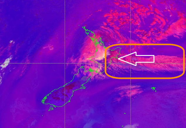 Mid-afternoon Friday over New Zealand, the area highlighted shows his narrow band of rain being fed into the east of the North Island. It’s gradually sliding northwards and will go out to sea overnight/Saturday morning. Data courtesy JMA, InfoGraphic by WeatherWatch.co.nz
 The airflows around New Zealand shows how the sub-tropical air, bringing in all that moisture, is hitting the very cold south to south east flow – turning heavy rain to heavy snow higher up. Data courtesy US Government/Earth.nullschool.net, InfoGraphic by WeatherWatch.co.nz
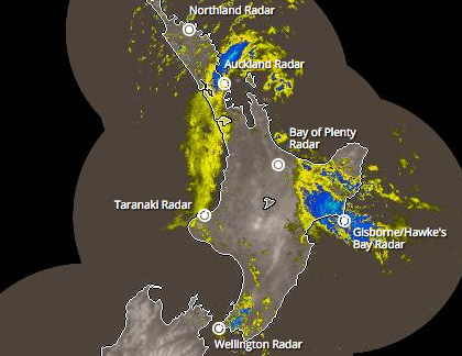 2:15pm public rain radar shows downpours till affecting the ranges of Wellington and southern Wairarapa, meanwhile the main rain band (that brought some flooding to Wairarapa and Manawatu overnight0 is sliding up the eastern coastline and already lies over Northern Hawke’s Bay and Gisborne. Some rain spilled over from Hawke’s Bay into Auckland, Waikato and western BOP early on – this is now clearing into Northland and weakening. Data funded by the NZ Taxpayer, provided by the NZ Government.
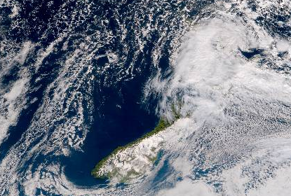 Friday afternoon satellite map again shows the power of the Southern Alps blocking cloud to the West Coast and parts of Otago and Southland. Meanwhile the North Island is smothered in a blanket of cloud. Image with thanks to JMA.
– WeatherWatch.co.nz
Latest Video

Cold weekend, frosts return with high pressure, then a low late next week
The subantarctic airflow spreads over NZ today/tonight and into Saturday, dropping temperatures nationwide. Snow flurries are possible today to lower…
Related Articles
Cold weekend, frosts return with high pressure, then a low late next week
The subantarctic airflow spreads over NZ today/tonight and into Saturday, dropping temperatures nationwide. Snow flurries are possible today to lower…

Wintry burst of weather: Snow, squally showers then sunshine & frosts
A polar change (another one!) arrives on Friday for the South Island and goes nationwide on Saturday, leaving NZ under…

Antarctic southerly for parts of NZ Fri & Sat
For the first time this year a southerly from off Antarctica is heading towards the South Island, followed by more…

