Heavy rain Tuesday for the West Coast, Moves into the North Island Wednesday
25/03/2018 10:50pm

> From the WeatherWatch archives
A cold front will move up the West Coast on Tuesday bringing slow moving heavy rain then at night moves into the lower North Island and begins to weaken for a time.
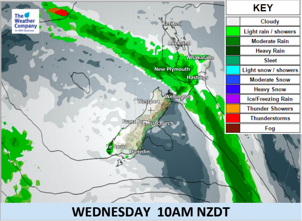
The front will continue tracking up the North Island over Wednesday and into Thursday before fading out sliding offshore by Good Friday.
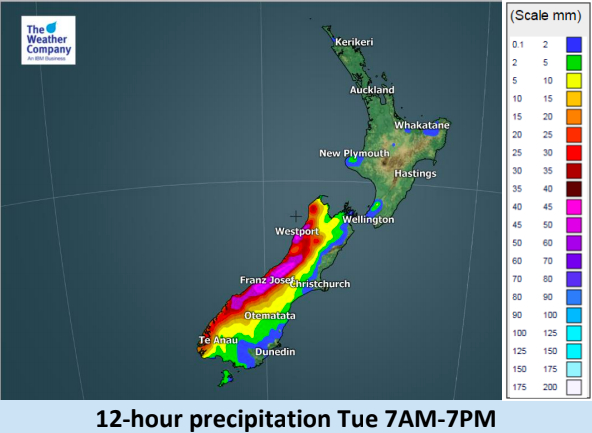
Rain will be heavy at times in the west, mostly the South Island’s West Coast.
Warmest weather will be in the east where places like Hawke’s Bay will be pushing into the late 20s for the next few days.
Main Weather Highlights:
- A well-marked cold front will cross the South Island from Monday night to Tuesday and weaken over the North Island on Wednesday.
- Nor’Westerly winds ahead of the front will bring persistent rain to Westland prior to and during the passage.
- Short-duration heavy rainfall of 20-30 mm/h is expected during the event on the West Coast. Higher values are possible depending on the local topography. Take care driving and watch for possible localised flooding.
- There is a large pressure gradient ahead of the front, supported by the existence of a large-scale high pressure system to the east of New Zealand. This provides strong winds over most areas in the South Island and southernmost part of the North Island.
- Gale winds are possible in exposed areas in the eastern part of the South Island on Tuesday.
- Hottest weather will be in the North Island’s east where highs of 27 or 28 degrees are possible on Monday and Tuesday.

– WeatherWatch.co.nz
Comments
Before you add a new comment, take note this story was published on 25 Mar 2018.
Latest Video

(VIDEO) NZ 7 Day: Variety in the weather, but Southern Ocean storms waking up
Low pressure moves in to NZ from the Tasman Sea this weekend and completely falls apart – bringing downpours and…
Related Articles
(VIDEO) NZ 7 Day: Variety in the weather, but Southern Ocean storms waking up
Low pressure moves in to NZ from the Tasman Sea this weekend and completely falls apart – bringing downpours and…

VIDEO: ClimateWatch: July is the month of BIG lows, BIG highs
This month around New Zealand, Australia and the region we see big highs and big lows – bringing decent stretches…

VIDEO: Severe weather risks for NZ as low moves in
Programming Note: Apologies but we have no video on Thursday – back again on Friday! – A storm in the…


Add new comment