Heavy rain, gale winds arrive – The Big Picture on Wednesday
12/07/2016 3:58am

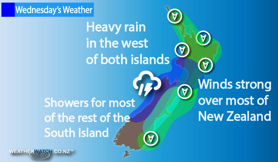
Here comes the winter we’ve all been waiting for! A large trough and frontal system is set to mix things up around the country for the rest of the week, affecting parts of both islands, and bringing some stormy conditions to some.
A front slowly moves northwards over the South Island during the day on Wednesday, reaching the lower North Island in the evening.
Expect heavy rain on the West Coast of the South Island, while there’s a chance of thunderstorms here also.
High cloud above in the east of the island, with strong to gale northerly winds blowing through.
Some spillover rain is possible at times in the east also, especially with the passing of the front.
Northerly winds through Cook Strait are likely to reach gale, as well as across western parts of the North Island during the evening and overnight.
The East Coast of the North Island sees strong northerlies develop overnight also, with a risk of gales by dawn on Thursday.
Rain spreads onto the west of the North Island – Taranaki southwards – in the evening, then elsewhere overnight. Rain in the west of the North Island may contain heavy falls.
– Aaron Wilkinson & Drew Chappell, WeatherWatch.co.nz
If you’re concerned about potential weather threats to your home, work or holiday – we recommend checking out the Civil Defence groups in your area, which can be found here.
Comments
Latest Video

Weekend Newsfeed: Warmer than average ahead of large low next week(+6 Maps)
Next week subtropical and subantarctic airflows will meet over NZ – and the forecast is still yet to be locked…
Related Articles
Weekend Newsfeed: Warmer than average ahead of large low next week(+6 Maps)
Next week subtropical and subantarctic airflows will meet over NZ – and the forecast is still yet to be locked…

VIDEO: NZ’s weather for the rest of July as large low looms again
High pressure and warm nor’westers are the theme of July’s final weekend – and the final week looks to be…

Thursday Newsfeed: High pressure moves closer to NI
High pressure over the Tasman Sea moves closer to the North Island encouraging milder nor’westers from Australia into the South…


Add new comment