Fronts moving into the South Island with some heavy rain in the west (+3 Maps)
7/12/2017 6:49pm

> From the WeatherWatch archives
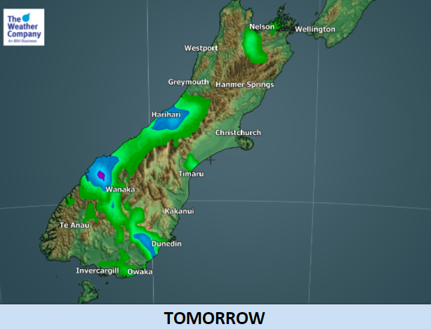
Despite two fronts expected in the South Island over the next day or two only a small amount of rainfall is expected across New Zealand, with the exception of the West Coast in the South Island.
Rainfall will be especially heavy around Mount Aspiring National Park into the afternoon. After such a long dry spell watch for rapidly rising rivers and possible slips.
There will be some ‘spillover’ into the east and south of the South Island but totals won’t be much – and for some it will just be a few spits that doesn’t even wet the ground.
Meanwhile the North Island looks mostly dry this weekend – but there are a few coastal morning drizzle patches possible in the north east on Saturday and a few isolated inland downpours on Sunday. The South Island rain bands are expected to crumble and fall apart as they move north (read WHY here).
The slightly changing weather means larger swells coming in around Tasmania and towards New Zealand – please keep this in mind with the warmer weather and sea temperatures as stronger rips and currents may form gradually in western and southern New Zealand beaches.


– InfoGraphics by The Weather Company (an IBM business and Official WeatherWatch.co.nz business partner)
– WeatherWatch.co.nz
Comments
Before you add a new comment, take note this story was published on 7 Dec 2017.
Latest Video

NZ VIDEO: Westerlies, lows, showers & large dry areas
Messy westerly driven weather will affect NZ this week, bringing more wet weather to western and northern parts of the…
Related Articles
NZ VIDEO: Westerlies, lows, showers & large dry areas
Messy westerly driven weather will affect NZ this week, bringing more wet weather to western and northern parts of the…

NZ VIDEO: Westerlies continue
Heavy rain and northerly gales are moving across NZ going into the weekend as a large low from the Tasman…

VIDEO: Low pressure, cold fronts, main feature next two weeks
There are several low pressure zones and cold fronts coming into NZ, with westerly driven weather dominating our weather pattern…


Add new comment