Cold front marches north, temperatures tumble behind it (Maps x 3)
3/05/2017 3:31am

> From the WeatherWatch archives
A cold front is moving up the South Island with heavy rain in the west and a cold southerly change spreading northwards behind the front for all regions.
As of 3:30pm the front was draped over West Coast and mid Canterbury with temperatures tumbling behind it.
In the north it’s warm in many eastern areas but clouds are thickening in western areas, including Auckland. It will make for a much milder night tonight ahead of the front following a cold night last night under clear skies.
The front is weakening as it heads north and in the early hours of Thursday it may well only bring a burst of downpours or rain lasting less than an hour.
The air temperature will drop nationwide over Thursday.
It’s short lived – a high starts to roll in for most regions by Friday and certainly will do so across the across the weekend.
 3:30pm wind map showing where the cold fornt is. Data via earth.nullschool.net
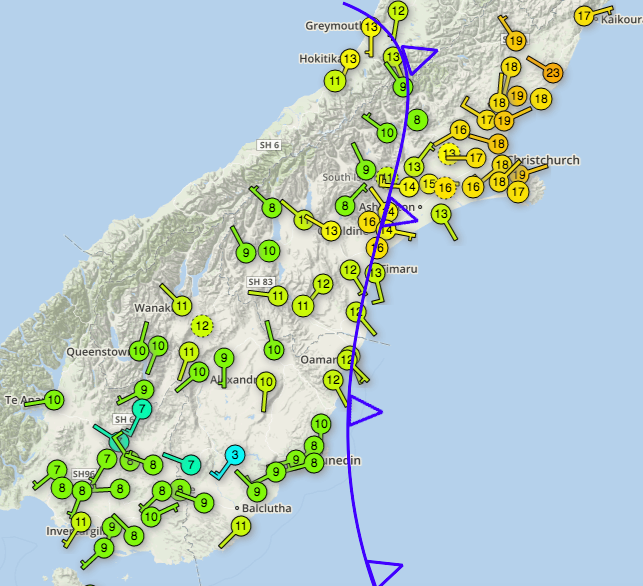 Temperatures as of 3:25pm Wednesday. Data courtesy Wunderground’s NZ community network
 Radar image as of 3:06pm. Rain radar funded by the NZ taxpayer, owned by the NZ Government
– WeatherWatch.co.nz
Comments
Before you add a new comment, take note this story was published on 3 May 2017.
Latest Video

NZ VIDEO: Severe weather going into the weekend. Next week: Westerlies continue
Heavy rain and northerly gales are moving across NZ going into the weekend as a large low from the Tasman…
Related Articles
NZ VIDEO: Severe weather going into the weekend. Next week: Westerlies continue
Heavy rain and northerly gales are moving across NZ going into the weekend as a large low from the Tasman…

VIDEO: Low pressure, cold fronts, main feature next two weeks
There are several low pressure zones and cold fronts coming into NZ, with westerly driven weather dominating our weather pattern…

VIDEO: Burst of wind and rain for NZ as low pressure dominates
Air pressure around New Zealand will continue to drop in the days ahead as low pressure systems affect our weather…


Add new comment