
> From the WeatherWatch archives
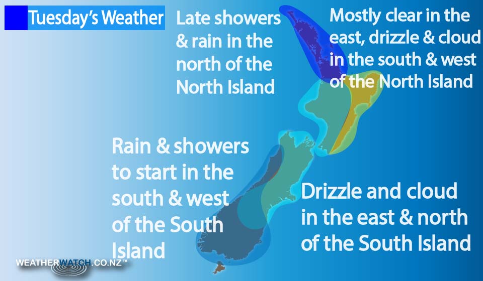
On Tuesday we have a west to northwesterly airflow over the North Island, before a front pushes into western areas late in the morning, running in a northwest to southeast orientation.
Another front moves onto the southwestern corner of the North Island during the late afternoon and into evening, then pushes northwards.
So for the North Island we have showers in the west, and high cloud out east – but showers pushing into the Wairarapa in the evening, and further north overnight.
For the South Island, we have a cool southerly change moving up the east coast in the morning, bringing cloudy skies and patchy showers or drizzle for most.
The West Coast sees morning rain clear, then sunny areas develop with southwest winds.
Otago sees any morning showers clear too, and sunny areas develop, along with breezy southwest winds easing later in the day.
– Aaron Wilkinson & Drew Chappell, WeatherWatch.co.nz
Comments
Before you add a new comment, take note this story was published on 11 Apr 2016.
Latest Video

(VIDEO) NZ 7 Day: Variety in the weather, but Southern Ocean storms waking up
Low pressure moves in to NZ from the Tasman Sea this weekend and completely falls apart – bringing downpours and…
Related Articles
(VIDEO) NZ 7 Day: Variety in the weather, but Southern Ocean storms waking up
Low pressure moves in to NZ from the Tasman Sea this weekend and completely falls apart – bringing downpours and…

VIDEO: ClimateWatch: July is the month of BIG lows, BIG highs
This month around New Zealand, Australia and the region we see big highs and big lows – bringing decent stretches…

VIDEO: Severe weather risks for NZ as low moves in
Programming Note: Apologies but we have no video on Thursday – back again on Friday! – A storm in the…


Add new comment
JohnGaul on 11/04/2016 7:44am
….so more settled weather to follow, how uninteresting.
Reply