Archives for September 2020

Temperature trends – An anticyclone brings a cold night ahead
Cold overnight temperatures can be expected for most of New Zealand tonight as shown in the map below. Light frosts…

VIDEO: Southerly blast next week, severe weather likely
There will likely be pockets of severe weather next week, wind and rain and maybe some snow higher up. The…

RainWatch – Showers in the east, may be a heavy shower mid to late afternoon in the west
Expect showers for the east coast of the North Island today with cold south to southwesterly winds. Drier for the…

Friday’s national forecast
A ridge pushes onto the South Island today with cold southerly quarter winds easing. The North Island has a wet…

Temperature trends – A cold southerly airflow lies over the country tonight – also heavy showers in Canterbury
A cold southerly airflow lies over New Zealand tonight and this is reflected in colder than average overnight lows for…

VIDEO: Wintry blast next week – weather warnings possible
We have a series of highs and cold fronts coming – with the peak next week. It makes the colder…

RainWatch – Rain for the South Island moves into the lower North Island this afternoon
The odd shower for the western North Island today. A southerly change pushes into the lower North Island this afternoon…

Thursday’s national forecast
A cold front pushes off the upper South Island this morning, onto the lower North Island this afternoon then upper…

Temperature trends – Colder than average tonight in the far north
A ridge of high pressure clings on to the far north of the North Island tonight, there will be some…
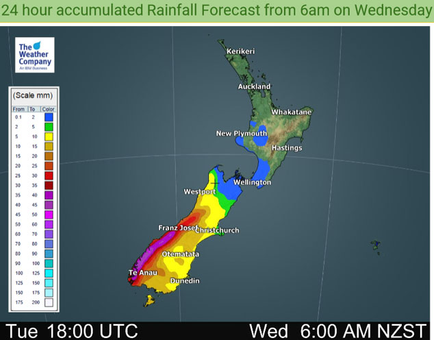
RainWatch – A cold front moves into the lower South Island this afternoon bringing rain
Rain moves into Southland early afternoon then Otago late afternoon with a cold southwest change, rain pushes northwards this evening…

