Weather Forecast for Rawene, Kaikohe, Northland14m above sea level
Now
Today
Tonight
Next 24 Hours in Rawene, Kaikohe, Northland
Next 9 Days in Rawene, Kaikohe, Northland
Day
Night
10km/h
chance
of rain
trace
Day
Night
16km/h
chance
of rain
trace
Day
Night
16km/h
chance
of rain
trace
Day
Night
16km/h
chance
of rain
trace
Day
Night
16km/h
chance
of rain
trace
Day
Night
15km/h
chance
of rain
trace
Day
Night
15km/h
chance
of rain
trace
Day
Night
14km/h
chance
of rain
trace
Day
Night
15km/h
chance
of rain
0.9mm
Comments
If you have any questions about functionality of our website(s) or app, trying to locate maps or data, or have a simple comment/feedback - please post a comment below!
As of 2024 we will no longer be publishing questions related to weather forecasts if they are answered via our hyper-local hourly & 10 day forecasts, weather maps and regular daily and monthly weather & climate videos.
We’re a small NZ business with limited resources to respond to general weather questions. Our social media pages may be helpful to you, especially if you want to often talk (or groan!) about your local weather. You can find more resources from us here if that’s your thing.
Have questions of a commercial nature? Contact us directly here.
Thanks for your support!
Don’t forget to check out our RuralWeather.co.nz website (great for event planning or attending + camping!) and also, our brand new Weather Alerting App!
Latest Video
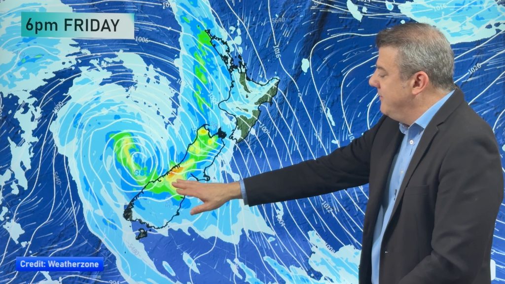
Colder change moving in this weekend, frosts for some next week
Low pressure will cross over the South Island on Friday night bringing more heavy rain to western and northern parts…


Add new comment
Blake Harvie on 6/05/2026 1:58am
The weatherwatch ‘day’ starts at 7am and finishes at the same time the following day. A 24 hour period.
Are you satisfied that this best meets the needs of your viewers?
It’s confusing somewhat I feel. I could look at Thursday for example and there’s no rain predicted… when in fact there might be a strong possibilty of rain on Thursday between 0000 and 0700. But you’ve accounted for that rain on Wednesday. It’s just not correct. A civil/calendar day would be better in my opinion.
Cheers,
Blake
Reply
WW Forecast Team on 6/05/2026 2:10am
Hi Blake, that is the way the data is delivered to us and currently we don’t have a work around for it. Visit RuralWeather.co.nz or download our app for clearer rain graphs.
Kind regards,
– WW
Reply
Colin Gibbs on 30/04/2026 12:00am
Hi, there is a lot of noise on social media and news sites about the El Nino this year. Maybe you could do a video with the facts as they are known as of now?
Reply
WW Forecast Team on 30/04/2026 12:13am
Hi Colin, we will do next week 🙂
– WW
Reply
josh on 30/04/2026 12:57am
drought for Auckland and for places that been flooding last 4-5 years?
Reply
Anne on 21/04/2026 7:39pm
Thurs 23, says 0% chance of 5.5 ml of rain …
I realise that forecasts are only a ‘best guess’ and can change at any time, but this seems to me on of the weirder ones, would love to know if there is an explanation
Reply
WW Forecast Team on 21/04/2026 8:07pm
Hi Anne, our rainfall data each day in the daily totals is actually broken into two segments: Daytime and nightime. So if you see that it means rainfall will be occuring overnight. If you use the rain graphs at RuralWeather.co.nz or in the WeatherWatch App you will be able to make more sense of it.
Kind regards
– WW
Reply
View more comments