Weather Forecast for Port Charles, Coromandel, Waikato5m above sea level
Now
Today
Tonight
Next 24 Hours in Port Charles, Coromandel, Waikato
Next 9 Days in Port Charles, Coromandel, Waikato
Day
Night
36km/h
chance
of rain
trace
Day
Night
44km/h
chance
of rain
trace
Day
Night
37km/h
chance
of rain
trace
Day
Night
32km/h
chance
of rain
1.5mm
Day
Night
32km/h
chance
of rain
14.1mm
Day
Night
30km/h
chance
of rain
3.4mm
Day
Night
27km/h
chance
of rain
0.8mm
Day
Night
28km/h
chance
of rain
trace
Day
Night
23km/h
chance
of rain
trace
Comments
If you have any questions about functionality of our website(s) or app, trying to locate maps or data, or have a simple comment/feedback - please post a comment below!
As of 2024 we will no longer be publishing questions related to weather forecasts if they are answered via our hyper-local hourly & 10 day forecasts, weather maps and regular daily and monthly weather & climate videos.
We’re a small NZ business with limited resources to respond to general weather questions. Our social media pages may be helpful to you, especially if you want to often talk (or groan!) about your local weather. You can find more resources from us here if that’s your thing.
Have questions of a commercial nature? Contact us directly here.
Thanks for your support!
Don’t forget to check out our RuralWeather.co.nz website (great for event planning or attending + camping!) and also, our brand new Weather Alerting App!
Latest Video
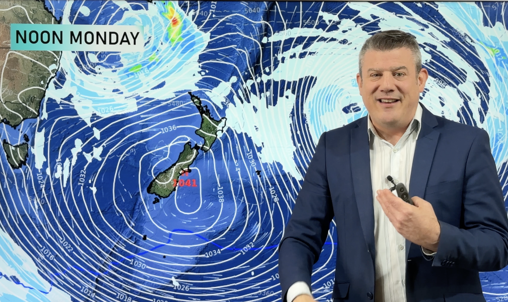
NZ VIDEO: Frosts & huge high pressure – August kicks off settled
Most places are dry over the weekend ahead – and next week too, as high pressure crosses NZ and dominates….


Add new comment
Sandra on 2/08/2025 5:41am
What was the degree of frost in Rangiora this morning, 2nd August please ?
Reply
jet on 1/08/2025 12:54am
Hi phill what’s causing Nelson’s showers next week even though we have high pressure?
Reply
WW Forecast Team on 1/08/2025 3:04am
Hi Jet, end of next high pressure moves east of NZ and just before the next big high moves in to the country there is a small area of rain/showers trapped in between over the South Island for a time.
– Phil
Reply
josh on 30/07/2025 10:06pm
hey weatherwatch team. josh again. i first heard about the rtsunami from this site. thanks for letting us know. emergency alerts kept me awake much of the night. a surreal week. orange rain warnings and now tsunami adversaries with some feeling/seeing it happening already!!!!
Reply
WW Forecast Team on 30/07/2025 10:28pm
Cheers Josh. Funny you say that, as this is the third time in a decade I’ve finished covering a severe weather event and then juuust as it ended and everything goes quiet, a tsunami alert is issued for the entire Pacific 🙂 No rest for the wicked!
Phil D
Reply
josh on 29/07/2025 10:03pm
95mm here in my location in takanini south auckland overnight and yesterday from the atmospheric river. models did a good job with this event. are we heading into a la nina?
Reply
WW Forecast Team on 29/07/2025 10:07pm
Hi Josh, yes modelling was really good with this event, definiely a soaking for many regions in the north. There’s a little bit of chatter about La Nina later this year, but for now it looks NEUTRAL still until December.
– WW
Reply
josh on 29/07/2025 10:29pm
the rain radar was showing it moving at a similar direction to the january 27 2023 atmospheric river i noticed. been very wet recently.
will we see more of these heavy rain event? looking forward to the next climate update. you guys do a brilliant job already heading into august.
Reply
josh on 30/07/2025 1:21am
tsunami alert? wow.
Reply
View more comments