Updated Maps (x4) – Rain, snow and windy weather moving up NZ Sunday & Monday
8/07/2018 8:33am

> From the WeatherWatch archives
Rain continues in western regions bringing a period of heavy rainfall reaching 30mm per hour in some areas. Northerly winds and wind gusts will be enhanced and possibly exceed 120 km/h before the passage, mainly in the ranges and exposed parts of the east/central NZ. Elsewhere just a bit blustery, nothing to stress about.
Due to the surge of cold air behind the front very isolated thunderstorms are expected in western coastal areas and also potentially Wellington in the North Island.
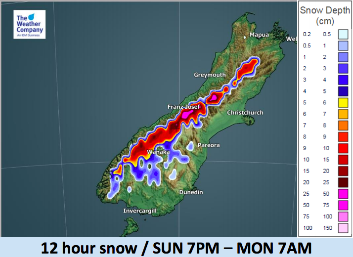
A heavy burst of snow is expected over the Southern Alps and surrounding hilly regions on Sunday night.


– WeatherWatch.co.nz
Comments
Before you add a new comment, take note this story was published on 8 Jul 2018.
Latest Video

NZ VIDEO: More lows, but a reduction in severe weather
More low pressure is coming in to New Zealand this week – but rainfall isn’t as dramatic as previous weeks,…
Related Articles
NZ VIDEO: More lows, but a reduction in severe weather
More low pressure is coming in to New Zealand this week – but rainfall isn’t as dramatic as previous weeks,…

NZ VIDEO: Westerlies, lows, showers & large dry areas
Messy westerly driven weather will affect NZ this week, bringing more wet weather to western and northern parts of the…

NZ VIDEO: Westerlies continue
Heavy rain and northerly gales are moving across NZ going into the weekend as a large low from the Tasman…


Add new comment