
> From the WeatherWatch archives
It’s been talked about for almost two years in the global scientific community and now it’s finally showing up on weather stations here in New Zealand – El Nino, the weather/climate event that often causes great concern in the rural sector.
But should be we concerned ? Short answer – yes, somewhat – long answer, yes, but let’s not get carried away, NZ can buck the international trends and we are still not 100% sure how this will all pan out over summer.
So saying things like “This El Nino will be worse than the drought creating one of the 1990s†is a bit like saying a newly developing tropical low is going to hurt NZ more than Bola did. But until it fully forms and until we really get a good feeling as to how it’s going to impact New Zealand, then we need to take a deep breath and not talk about extreme worst case scenarios as if they are locked in with certainty…because we simply don’t know this early.
New Zealand’s farming industry, particularly dairy, has enough stresses at the moment without forecasters piling in on El Nino to get some big news headlines.
We can’t say for sure how severe it will be until it really gets going. Right now – it’s nothing too severe.
So for now – let’s stay positive and know that no matter how severe El Nino becomes, New Zealand is mostly two large mountainous islands in the roaring 40s – in other words, even a doom and gloom El Nino forecast can have silver linings for a country this small.
If things start to look dire – we’ll be the first to educate you on what this means. But for now – it’s very early days and, generally speaking, the weather across NZ has been pretty kind to New Zealand farmers and growers this winter, despite the odd snow and flood event.
WHAT IS EL NINO?
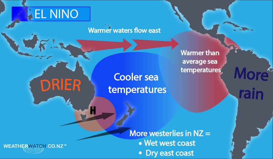
Quite simply, El Nino is a set up when the warmer waters of the Pacific Ocean, near the equator, are blown towards South America and away from New Zealand and Australia. This creates a large area of warmer than average sea surface conditions in the eastern Pacific (we are south western) – this helps makes more lows which causes rain and floods for western areas of the Americas. But here in New Zealand and Australia the cooler ocean waters means we have less sub-tropical lows and more highs parked over the Tasman Sea.
It’s the location of these frequent highs (over the Tasman Sea) that can give New Zealand some headaches during El Nino springs and summers
It encourages more west to south west winds – in turn that puts more rain clouds on the west coast and much drier, windier, weather in the east. It can then lead to droughts inland and in our east if it continues for several months.
Or put another way – a similar weather pattern to the one we’ve seen these past few weeks – a lot of westerlies, a lot of dry in the east and wet in the west.
That’s the reason there is concern with El Nino – because we already get a lot of westerlies heading into summer (spring pattern) and El Nino basically amplifies this. Making wets wetter and drys drier.
But remember, New Zealand is two small islands in the South Pacific – so even if El Nino forms, our weather can still be varied and changeable – all it takes is one sub-tropical low or ex-cyclone and we can get rains.
SO, WHAT IS LA NINA THEN?
The opposite of El Nino. It’s when that warm water gets blown westwards towards New Zealand and Fiji and Australia. We get more humidity, more rain and more tropical cyclones. La Nina often affects the North Island even more, as it’s exposed to the sub-tropical lows and high humidity. La Nina summers can be hot, humid but sometimes quite cloudy. La Nina can be wet for holidaymakers but good for dairy farmers.
El Nino summers tend to be good for holidaymakers (apart from a bit windy in December) but not so positive for those who rely heavily on rain water through the summer months (like many farmers and those in rural/isolated areas/smaller islands).
.
– WeatherWatch.co.nz
Comments
Before you add a new comment, take note this story was published on 7 Aug 2015.
Latest Video

NZ VIDEO: More lows, but a reduction in severe weather
More low pressure is coming in to New Zealand this week – but rainfall isn’t as dramatic as previous weeks,…
Related Articles
NZ VIDEO: More lows, but a reduction in severe weather
More low pressure is coming in to New Zealand this week – but rainfall isn’t as dramatic as previous weeks,…

NZ VIDEO: Westerlies, lows, showers & large dry areas
Messy westerly driven weather will affect NZ this week, bringing more wet weather to western and northern parts of the…

NZ VIDEO: Westerlies continue
Heavy rain and northerly gales are moving across NZ going into the weekend as a large low from the Tasman…


Add new comment
Ian Cooper on 11/08/2015 12:09am
Well written team. I like that you have tried to defuse the hype. Far too early for that.
As with floods & droughts no two El Nino events are the same. many similarities but not identical. The Big Bad El nino of 1982-3 sticks long in the memory for both east & west coasters. Severe drought from East Cape to Dunedin. The worst bout of west to Nor’west winds I can recall in the past six decades for the Manawatu. They weren’t continuous but there was little let up from the end of August ’82 through to the end of March ’83. A severe Australian bushfire season also ensued that year so watch out for that if it gets bad.
Just one thing. Strictly speaking La Nina isn’t the ‘opposite’ of El Nino. La Nina is the other phase of the ENSO (El Nino Southern Oscillation) but it doesn’t actually make it the opposite even in simple terms. The other thing to remember for the NZ situation is that we are often out of phase with the US, so what the iternational news media says about ENSO doesn’t necessarily apply to us. As an example for the US La Nina is referred to as a cold event, but in NZ we often get our hottest summers when the ‘girl child’ comes to town, even if she tends to drag a few ex-tropical cyclones with her!
We an only hope that this El Nino isn’t severe. Nothing worse than an El Nino spring in New Zealand.
Reply
Guest on 8/08/2015 1:03am
What does it mean for Auckland?…. Although it’s not all about us!
Reply
WW Forecast Team on 8/08/2015 2:42am
Usually more westerlies and cloud – may not be wetter though.
– Cheers!
Reply
Matt on 7/08/2015 9:28am
Good to see someone explaining El Nino in terms the masses will understand WW.
However, I do feel that you focused too much on the weather effects it has on NZ(I know, I know, you are WeatherWatch),
but didn’t really touch on the oceanic effects or causation(wave types that cause/stop it, trade winds or nutrient upwelling). Nor how the positive feedback loop works.
Maybe you could do a slightly more detailed post focusing less on NZ and more on the cycle.
Reply
Derek on 7/08/2015 6:00am
An excellent article Weather Watch. I hope the media use this in priority parts of their newspapers so the public can get positive information rather than the headliners you mention.
Thank you for this.
Reply
Serenity on 7/08/2015 4:56am
does the Far North get lumped into the West category (eg wetter) during El Niño?
Reply
WW Forecast Team on 7/08/2015 10:05pm
Hi there – Northland is both west and north. El Nino can be a bit dry for you inland and the east – but you’re also quite exposed to sub-tropical showers/rain, which helps. Certainly the current pattern is delivering plenty of wet weather to the north (amongst the wind and sun)
– WW
Reply