Cold blast number 1 arrives, cold blast number 2 is on the way (+4 Maps)
22/05/2018 10:52pm

> From the WeatherWatch archives
The first of two significant polar blasts is today covering New Zealand bringing thunderstorms, hail, snow and miserable conditions to those outdoors.
Mostly or partly sunny weather is dominating the east of the North Island and many parts of the South Island due to the air flow and the mountains/ranges blocking some rain clouds. If this hasn’t happened yet it may happen later this afternoon as the North Island cold front moves away from the island.
Temperatures are lower than usual in most areas. Minimum temperatures are much more significantly affected with overnight lows possibly down to -8C in Queenstown tonight, -3 in Wanaka and -4 tomorrow in Alexandra.
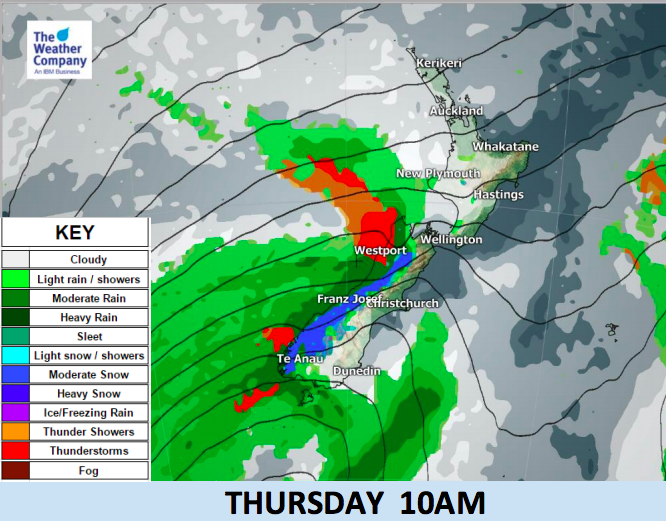
Today New Zealand is located behind the cold front but another cold front is approaching to bring more snow, rain, wind, hail and thunder from late Thursday and across Friday. This next front will be as strong as the last one on Tuesday/Wednesday and will again cause NW gales over the interior and eastern South Island during Thursday daytime and later into Cook Strait and Wellington/southern Wairarapa. Although the amount of rain accumulation is lighter than the last event, snow accumulation is as heavy as the last event and is expected over mountainous regions.
From Thursday afternoon, snow or mixed precipitation is possible even lower down just west of the Southern Alps. The front will sweep the South Island northward and eventually bring thunderstorms in western and northern parts of the North Island from Thursday night and across Friday.


– WeatherWatch.co.nz
Latest Video

Cold weekend, frosts return with high pressure, then a low late next week
The subantarctic airflow spreads over NZ today/tonight and into Saturday, dropping temperatures nationwide. Snow flurries are possible today to lower…
Related Articles
Cold weekend, frosts return with high pressure, then a low late next week
The subantarctic airflow spreads over NZ today/tonight and into Saturday, dropping temperatures nationwide. Snow flurries are possible today to lower…

Wintry burst of weather: Snow, squally showers then sunshine & frosts
A polar change (another one!) arrives on Friday for the South Island and goes nationwide on Saturday, leaving NZ under…

Antarctic southerly for parts of NZ Fri & Sat
For the first time this year a southerly from off Antarctica is heading towards the South Island, followed by more…

