Big storm in the Southern Ocean, big high to the north, NZ in the middle (+5 Maps)
7/05/2018 10:33pm

> From the WeatherWatch archives
New Zealand is in an air pressure sandwich today with a big high moving towards the upper North Island at the same time as a big storm churns by well south of the lower South Island, nearer to Antarctica.
The centre of the deep storm in the Southern Ocean (central air pressure is forecast to be a very low 950hPa) will stay well south of New Zealand but the pressure gradient between the big high to the north and the large low to the south means windy weather will blow over the South Island with gales today as this storm rolls by.
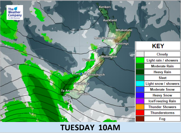
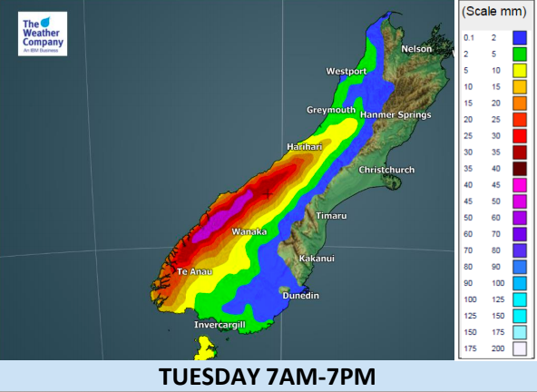
Winds will combine with rain as well, on the West Coast, which may be heavy at times.
However by Wednesday the centre of a large high will be slowly rolling into Northland and Auckland extending a ridge of high pressure (calmer weather) across the country, including the South Island by afternoon. The storm in the Southern Ocean will be quickly zipping away by then too as we’re only being brushed by the outer edges of it.
The warm winds on Tuesday will create afternoon temperatures higher than usual for May. Over the next couple of days some parts of eastern New Zealand will be sunny and warm with highs into the mid 20s possible – several degrees above average for the second week of May.

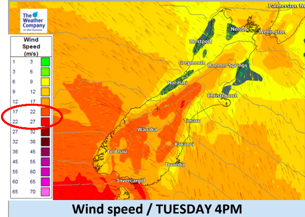 – Gale force winds are highlighted in orange/red
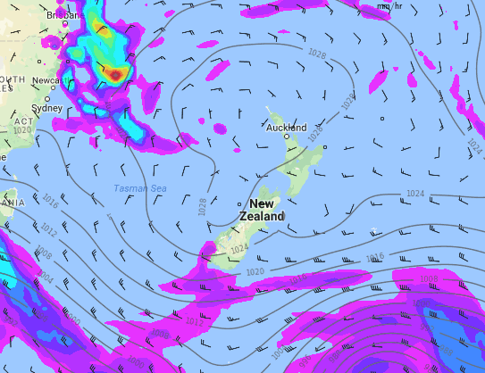 – Noon Wednesday shows a large high centred over northern New Zealand and the big storm in the Southern Ocean that brings the wind and rain on Tuesday departs to the south east of NZ. Map by weathermap.co.nz
– WeatherWatch.co.nz
Latest Video

Matariki, the long weekend + the outlook for next week
Wet weather and cloud continues along the eastern side of the country with the heaviest rain now moving into northern…
Related Articles
Matariki, the long weekend + the outlook for next week
Wet weather and cloud continues along the eastern side of the country with the heaviest rain now moving into northern…

More eastern rain, but a drier long weekend coming
Rain continues today along the eastern South Island and lower North Island, coming in from the east with heavy falls….

More heavy rain, snow – but large dry areas, especially as we go into the long weekend
Heavy rain will continue for parts of Canterbury and Marlborough over the next day or two and it will gradually…

