Winston peters out… Northland relieved (+3 maps)
25/02/2016 2:48am

Tropical Cyclone Winston is no more. The storm has this afternoon weakened to the point it is no longer a technical tropical cyclone. The storm is also right on the borderline of losing gales at the centre – but still has winds of between 60 and 90km/h.
The central air pressure on Thursday afternoon puts ex-cyclone Winston in the 990 hPa range. It was 915hPa on Saturday morning.
The centre of Winston lies about 900kms north of Cape Reinga, while the humid nor’east flow to the south of the low (between Winston and a high centred west of Taranaki) is increasingly spilling down over New Zealand.
While Northland is exposed to some high cloud and building nor’easters – plus some bigger swells and rips – the region won’t be directly hit by this ex-cyclone.
Will Winston hit New Zealand?
The short answer is no. The long answer is, sort of. Winston is pulling down more tropical air and, coupled with the high, will drag subtropical air over the country, in particular northern New Zealand, this weekend and start of next week.
In conjunction with a southerly cold front the warm and cold air masses may create for localised heavy rain and showers over the North Island this Sunday and Monday. Perhaps even late on Saturday for some in the west.
Winston won’t directly hit NZ – but tropical air following it will come down and help feed these rain bands around the North Island. Very hit and miss – but could be some significant slow moving downpours draped across some regions.
FUTURE OF WINSTON?
Today Winston has weakened and is no longer a technical tropical cyclone. South Pacific weather authorities are traditionally very slow at getting info out to the public but the US Joint Typhoon Warning Center in Hawaii and NZ’s MetService have both confirmed the storm is no longer “tropical”. Ex-cyclone Winston will move out into the Tasman Sea and fall apart over the weekend, drifting towards the Brisbane/Queensland coast area as a very weak system.
However, the low is still a low and WeatherWatch.co.nz will closely monitor the ex-cyclone incase it fires back up again in the warmer conditions around Australia.
For now though, you may be pleased (or not) to know this is our last Winston-specific news update, after what has been two and half weeks of painful tracking with computer models utterly thrown by this particular storm. For two weeks Winston has posed a moderate threat to New Zealand – but high pressure directly over the North Island has kept the low away from us. While anyone can report on models, it’s our job as forecasters to find patterns and likely outcomes amongst the data – this has not been easy, and explains why on Tuesday our two government forecasters had two entirely different forecasts.
WeatherWatch.co.nz will continue to track Winston and the remnants – especially this small area of possibly heavy rain which may cross some North Island regions in the coming days. But with the storm so much weaker and smaller entire updates based around this one low will stop after today.
 CURRENT WIND MAP / EARTH.NULLSCHOOL
 Close but not close enough – the Final Warning map from the Joint Typhoon Warning Center on ex-cyclone Winston.
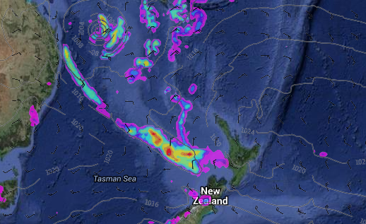
Saturday’s rain map shows ex-cyclone Winston in the Tasman Sea helping trigger a band of heavy rain just west of Taranaki – it’s this tropical fuelled band of rain and showers that look likely to cross the North Island over Sunday and Monday. / Weathermap
– WeatherWatch.co.nz
Comments
Latest Video

VIDEO: NZ’s Autumn showers + sub-tropical developments
NZ has a classic Autumn sou-wester today and this eases into Friday and the weekend. Next week low pressure forms…
Related Articles

Weekend Newsfeed: SW flow eases, high pressure starts to grow around NZ
The cooler SW flow of this week is going to fade more going into the weekend as high pressure develops…
VIDEO: NZ’s Autumn showers + sub-tropical developments
NZ has a classic Autumn sou-wester today and this eases into Friday and the weekend. Next week low pressure forms…

Thursday Newsfeed: A south-west flow across the country
A south-westerly flow has spread across NZ and will continue to do so for Thursday, Friday and Saturday. Windiest weather…


Add new comment
Guest on 25/02/2016 6:59am
I hear Winston has been making waves in Northland, however…
Reply
Guest on 25/02/2016 5:29am
promise a lot and deliver nothing hahaha
Reply
Guest on 25/02/2016 2:34am
hahaha… how long have you been waiting to use that one 🙂
Probably the funniest/cleverest weather headline ever. Well done!!
Reply