Vanuatu, New Caledonia on alert as Tropical Cyclone formation begins (+6 maps)
6/03/2018 4:02am

A storm is developing near Vanuatu and is almost at tropical cyclone status with sustained winds circulating around the low at just below gale force and air pressure around 1000hPa. When winds reach gale force (63km/h) at the centre it will be given the name “Hola” by the Fiji Met Service and it will be a category 1 cyclone.
According to the Fiji Met Service there is a high chance of this cyclone forming and the American Joint Typhoon Warning Center expects a tropical cyclone to form within 24 hours.
The Vanuatu Met Service has already started issuing tracking maps – currently for a tropical low but as the low crosses Vanuatu and lies just to the west of the nation (and just north of New Caledonia) it’s expected to stall for a few days and deepen in to, potentially, a “severe” tropical cyclone.
It’s unclear how this low will precisely track but most modelling shows it drifting a little west of Vanuatu, deepening, and then tracking slowly south to south east back towards southern Vanuatu.
The modelling shows it remaining at sea for much of the time but as we know cyclones can have a mind of their own in the tropics so New Caledonia is also quite exposed to being directly in the path of this storm.
As for further south into the New Zealand area most modelling agrees it will track over New Zealand waters but it’s very unclear what might happen in New Zealand. There is still a lot of uncertainty about how this storm might track south out of the tropics so we cannot be more precise about New Zealand yet.
Many of you are asking us to compare this to Gita – but as we said with Cyclone Gita every cyclone is unique and tracks in a unique way. The modelling is less clear with this low than the previous two tropical storms in our view for New Zealand.
VANUATU and NEW CALEDONIA RISKS:
The main focus for now should be on Vanuatu. Heavy rain at the centre of this tropical low tracks over Vanuatu on Wednesday. Around noon Wednesday the centre of the low may be over the top of the capital Port Vila. The following 48 hours the storm – based on modelling – will lie out at sea to the west of Vila and north of New Caledonia. Over these 48 hours the storm could deepen significantly with air pressure estimated to drop from 993hPa at noon Thursday to 962hPa by midnight Friday. If it goes this deep it could make it a ‘severe’ category 3 storm. It may then drift south to south east towards the southern islands of Vanuatu or New Caledonia. Remember the cyclone has not technically formed yet so precise tracking beyond a couple of days is still quite unclear.
NEW ZEALAND RISKS
As we said above, it’s still too early to know if New Zealand might be impacted by this likely tropical storm however reliable computer modelling does show this tropical storm coming into the New Zealand area. By “area” we mean either land or remaining out at sea entirely, but over New Zealand waters and close enough to bring dangerous coastal conditions.
Most modelling is still picking this storm to zip by at the weekend well to the east of East Cape. But some modelling, such as ECMWF out of Europe, has been showing a much closer North Island track with even one update today showing a more direct path to Northland – but this is so far an isolated single update. So until the various computer modelling is more aligned we can’t be precise on if it may be a serious concern for New Zealand – or simply and offshore low that brings coastal risks only. It may even bring no risks if it weakens more than the computer modelling suggests.
Even if Cyclone Hola misses land it could create big swells and dangerous rips and random large waves at beaches that have locally settled and sunny weather. In the past offshore cyclones around New Zealand haven’t had a lot of focus yet they have lead to drownings in unexpected places here along with dangerous rips which have seen many people caught up and rescued.
For now the focus remains on Vanuatu. Remember our maps here at WeatherWatch.co.nz are made with GFS data so you can track that particular model (from America) in more detail over the coming days – and we also have a link at our Maps page for ECMWF models too.
Remember – as of 5pm Tuesday there is no active tropical cyclone yet. WeatherWatch.co.nz is using the same data we used to monitor Cyclone’s Gita, Fehi and Cook in recent history but as we say every cyclone is unique and has unique challenges in tracking.
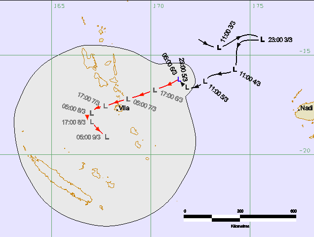 – Vanuatu Met Service tracking
 – Fiji Met Service cyclone development risk map
 – JTWC (Joint Typhoon Warning Center / US Govt) showing the Cyclone Formation risk zone.
ECMWF (Europe) modelling showing the low tracking west directly over Port Vila as either a Tropical Low or a low end Category 1 cyclone on Wednesday. Then the low rapidly deepens, potentially reaching Category 3 status. This is the a projection based on ECMWF modelling.
3PM WEDNESDAY: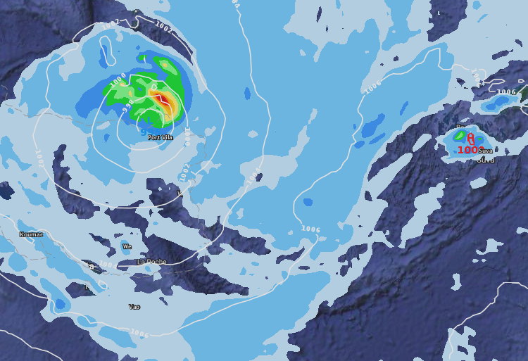
9PM FRIDAY (30 hours after the map above)

– Earth.nullschool.net wind map for Tuesday afternoon shows the tropical low developing just east of Vanuatu and well west of Fiji
– WeatherWatch.co.nz
Comments
Latest Video

VIDEO: NZ’s Autumn showers + sub-tropical developments
NZ has a classic Autumn sou-wester today and this eases into Friday and the weekend. Next week low pressure forms…
Related Articles
VIDEO: NZ’s Autumn showers + sub-tropical developments
NZ has a classic Autumn sou-wester today and this eases into Friday and the weekend. Next week low pressure forms…

Thursday Newsfeed: A south-west flow across the country
A south-westerly flow has spread across NZ and will continue to do so for Thursday, Friday and Saturday. Windiest weather…

ClimateWatch: MAY’s outlook as El Niño ends, NEUTRAL pattern arrives (+Video & 13 Maps)
El Niño may be technically gone but the weather pattern it created is still with our part of the world. By…


Add new comment