
Typhoon Hagibis is a large scale and a violent storm moving quickly northwestward at around 12kt (22kmh)
It will likely make a northeastward turn around Friday evening. After the turn, it will be accelerated by westerlies – the faster it moves the less impact the rain will have but it can help push up winds in front of the storm.
As Hagibis is a large system, the impact will start well before possible landfall. Torrential rain and gusty winds will commence over Tokai and Kanto region from Friday night.
The heaviest rain will be across Kii Peninsula to Izu Peninsula on Friday, totals of more than 200 mm/24 hours.
One of the major concerns will be gusty winds on Saturday. It will impact Chiba Pref, which is now on the way to reconstruction from the damages by an earlier storm.
Also, special attention to storm surge is required along coastal areas facing to the Pacific Ocean especially because a spring tide will concur.
Max temperatures will be much warmer than normal until the storm goes off.
Our thanks to our partners at The Weather Company/IBM for helping with this story.

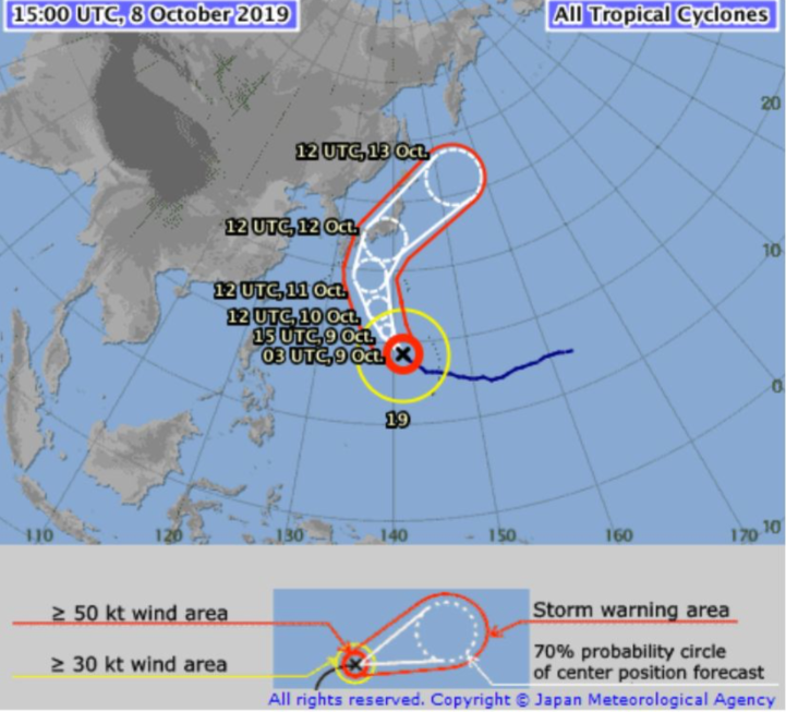
ABOVE – CURRENT POSITION
BELOW – WHAT THE MODELS SAY – COMPARING 3 GLOBAL MODELS FOR STORM PLACEMENT THIS SATURDAY EVENING
BELOW – WHAT THE MODELS SAY – COMPARING 3 GLOBAL MODELS FOR STORM PLACEMENT THIS SATURDAY EVENING


– WeatherWatch.co.nz – Proudly an official IBM business partner
Comments
Latest Video

15/05/2024 5:00pm
Thursday Newsfeed: Autumnal weather means highs, lows & cold fronts
A windy sou’wester kicks in for northern NZ on Thursday while a cold southerly arrives in the lower South Island…
Related Articles

9/05/2024 4:09am
The solar winter has begun… the 3 darkest months of the year
While we’re still in Autumn the “Solar Winter” has just begun – the second week of May marks the three…

8/05/2024 11:56pm
VIDEO: Australia 7 Day Weather + Did you know this island existed between NZ & OZ?
Our place of the day today in our Aussie weather video is a remarkable old volcano smack bang in the…

5/05/2024 7:00pm
Meteors – Your Eyewitness Reports!
WeatherWatch.co.nz receives meteor reports from all over New Zealand and the globe, 24/7/365. **CASUAL COMMENTS**If you’ve seen something in the…


Add new comment