Northern NZ feels like the tropics + Cyclone Gita’s possible future track (+10 maps)
13/02/2018 1:39am

The upper North Island is officially wetter than it should be for this time of the year (no kidding!) as humidity up to 100% along with heavy rain and isolated thunderstorms continues today and to a lesser degree on Wednesday.
Water vapour satellite maps show the exceptionally damp airflow connecting to the tropics and even around the area Cyclone Gita is in.
Over the next 24 hours more rain will hover around the upper North Island but should ease back and eventually clear up for most places on Thursday and Friday.
This coming weekend Cyclone Gita is likely to be tracking into the north Tasman Sea. While it remains unclear how the storm might impact New Zealand it does look quite likely that another humid nor’east flow will kick in towards Sunday and Monday possibly bringing more sub-tropical rain, while the storm separately churns in the Tasman Sea.
WILL GITA HIT NZ?
We are being asked this daily and our response remains fairly unchanged. We have fairly high confidence that Gita will help influence our weather pattern, for example the nor’east flow and humidity coming in by Sunday or Monday for northern New Zealand.
The storm is also expected to start bringing in north east swells to the upper North Island as early as tomorrow, Wednesday. By this weekend northerly swells of 1.5 to 2 metres may be impacting the Far North and northern Northland. This could increase to 3 metres from the north to north west by the end of Sunday in places like 90 Mile Beach.
Weatherwise on land and the computer models – the many ones we check from sources like NASA to NOAA to JTWC to ECMWF to even Australia’s modelling services plus private data from IBM’s Watson Super Computer – have all been showing different things about the intensity and precise tracking of the low but are increasingly coming on to the same page.
While the various reliable models tend to all place New Zealand in the firing line they can’t agree on timing either leaving quite a wide window next week of possibilities – from a direct hit with storm conditions to a more lazy wet system coming in a few days later. Due to this uncertainty all we can do is continue to give you the latest updates and best thinking each day.
At this stage WeatherWatch.co.nz says dangerous marine conditions will be developing in northern New Zealand (check the swells maps) mainly from later this weekend. Rain may also start developing early next week with a chance of stormy conditions early next week. We have to say this is not yet locked in – but our confidence continues to slowly increase.
IS THERE A CHANCE THE CYCLONE COULD ENTIRELY MISS NZ?
There is always this chance when dealing with a cyclone. Remember while the storm is incredibly powerful the worst part of the damaging winds and torrential rain could fit inside the central part of the North Island. This means the various different tracks of the storm could have significantly different impacts on New Zealand. One computer model even picks it entirely missing New Zealand (although the majority do not). There’s also always the possibility of the storm weakening a lot before it reaches us – but most modelling doesn’t heavily suggest that. The storm will also soon be entering MetService’s area for coverage and so we expect them to start talking about it in more detail in the coming day(s).
It’s worth noting the storm’s path hasn’t changed a great deal from the original tracking we were looking at last week from various international models WeatherWatch.co.nz relies on and trusts. However the time it was expected to be in the NZ area has been stretched out further. As of today two of the world’s most trusted models from ECMWF (Europe) and GFS (US Government) place the storm to the north west of the North Island on Tuesday morning. This may still change – as those of you who follow the models closely would have noticed.
We’ll keep you update on the models and remember we don’t just report on what a computer model says, we also use a lot of other data, past history, New Zealand’s topography and current set up to all help work out the possible forecast and are also working exclusively with meteorologists on a daily basis at The Weather Company for additional New Zealand specific information.


 – Water vapour satellite map shows the smudge of white cloud indicating high amounts of water in the atmosphere (why we’re getting 100% humidity at times in the upper North Island!) and it connected to the Fiji area, including where the Cyclone is too. Image by Himawari (Japanese Government).
 – Future tracking from JTWC (Joint Typhoon Warning Center – US Government)
 – Spaghetti models, showing possible various tracks of the centre portion of the low from various international Government models – visit their website for more info: www.cyclocane.com/gita-spaghetti-models/
 – ECWMF placing the storm on Tuesday morning (please note this is just a snap shot of one possibility, this forecast may still change and has been changing around daily)
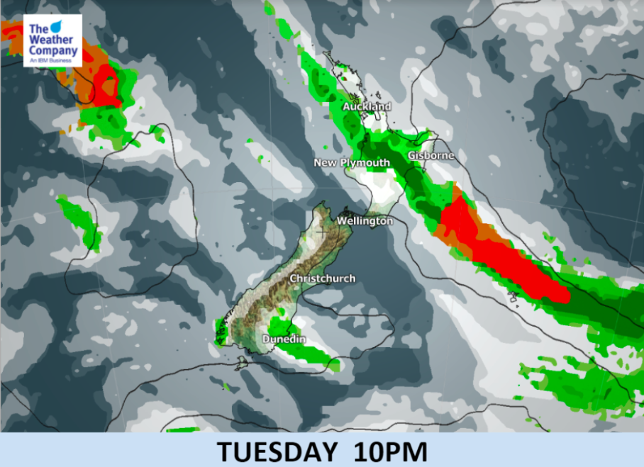
 – GFS model for Tuesday morning (US Government). This data is in the public domain and many of you are already seeing it and asking us about it. The maps we use on our website from MetOcean (which is now owned by MetService) also display GFS mapping. Remember this is just one computer model. Incidentally this is very similar to what GFS was saying a week ago. This may still change – as we’ve been saying in recent days the computers are still not yet locking in what might happen precisely in New Zealand next week. This is what we call “one to watch”.
– WeatherWatch.co.nz
Comments
Latest Video

VIDEO: NZ RainWatch -Not much coming next 7 days
High pressure is the main feature driving NZ’s weather for the next 10 days but low pressure is trying to…
Related Articles

Weekend Newsfeed: High pressure starts to grow around NZ, easterlies in the north
The cooler SW flow of this past week is going to fade more going into the weekend as high pressure…
VIDEO: NZ RainWatch -Not much coming next 7 days
High pressure is the main feature driving NZ’s weather for the next 10 days but low pressure is trying to…

VIDEO: NZ’s Autumn showers + sub-tropical developments
NZ has a classic Autumn sou-wester today and this eases into Friday and the weekend. Next week low pressure forms…


Add new comment
Dave on 13/02/2018 2:17am
Hi Phil
Great coverage again, wow they are picking it will still be Cat3 when well down the Tasman. If that is the case it will have a punch unless it stalls there for a while
Cheers
Dave
Reply