More details on Cyclone Gita as it approaches NZ (+7 Maps)
18/02/2018 11:35pm

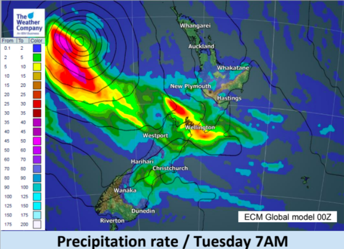
Tropical Cyclone Gita remains a Category 2 storm and is located in the central/northern Tasman Sea. Winds are sustained in the centre at around 95km/h.
Here’s the latest for New Zealand by qualified meteorologists at The Weather Company especially for WeatherWatch.co.nz.
- Gita will track southeastwards toward central New Zealand around Tuesday night/early Wednesday morning.
- On arrival Gita is expected to have maximum sustained wind speed of 85km/h (gale force is 62 km/h)
- The mountains and ranges will see gusts much higher.
- The interaction with an upper level cold pool leads the transition to an extra-tropical cyclone in the next 24 hours.
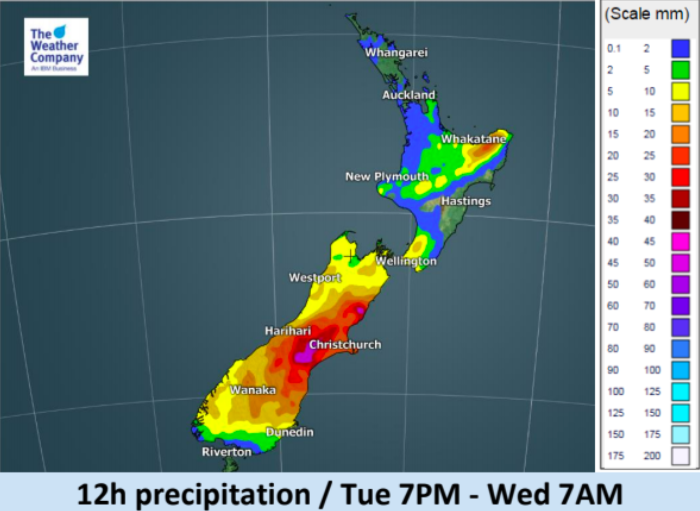
- On Tuesday, frontal rainfall over Wellington, Tasman, Nelson, and Canterbury will precede the arrival of Gita. Locally heavy falls for several hours are possible over those areas. Flooding is possible.
- The peak of rainfall in the northern part of the South Island will be during Tuesday night.
- Rain will continue into Wednesday mainly in the east of the South Island.
- Very dangerous seas and coastal conditions around the country, especially the west.
- Keep up to date with Government Agency MetService and their warnings, watches and outlooks.
Please note – Our next weather video update will be mid afternoon today, a bit later than usual as we work to fine tune the forecast.


– Tracking by JTWC (US Government), Weather maps by The Weather Company
– WeatherWatch.co.nz
Comments
Latest Video

VIDEO: NZ RainWatch -Not much coming next 7 days
High pressure is the main feature driving NZ’s weather for the next 10 days but low pressure is trying to…
Related Articles
VIDEO: NZ RainWatch -Not much coming next 7 days
High pressure is the main feature driving NZ’s weather for the next 10 days but low pressure is trying to…

Weekend Newsfeed: SW flow eases, high pressure starts to grow around NZ
The cooler SW flow of this week is going to fade more going into the weekend as high pressure develops…

VIDEO: NZ’s Autumn showers + sub-tropical developments
NZ has a classic Autumn sou-wester today and this eases into Friday and the weekend. Next week low pressure forms…


Add new comment